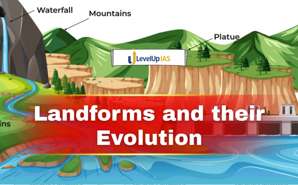
Landforms and their evolution
Content
- Introduction
- Fundamental Forces
- Geomorphic Cycle
- Landforms Produced by Endogenic Processes
- Landforms Produced by Fluvial Processes
- Glacial Landforms
- Aeolian Landforms
- Role of Structure, Climate, and Time
- Significance
Introduction
Landforms represent the visible physical features of the Earth’s surface created through the continuous interaction of internal (endogenic) and external (exogenic) forces. These features are not static; rather, they evolve over geological time through processes such as tectonic movements, volcanism, weathering, erosion, transportation, and deposition. The study of landform development forms the core of geomorphology, which explains how landscapes originate, transform, and attain equilibrium under varying climatic and structural conditions.
Understanding landforms is essential for UPSC preparation because they influence climate patterns, soil formation, river systems, biodiversity distribution, and human settlement patterns.
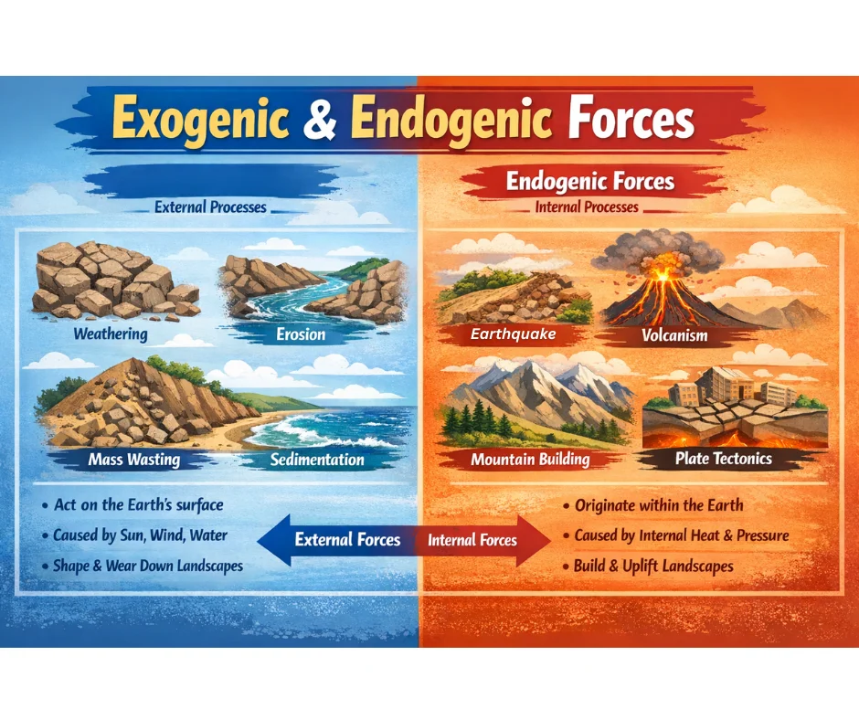
Fundamental Forces Responsible for Landform Development
The Earth’s crust is shaped by two broad categories of forces: endogenic forces originating within the Earth and exogenic forces operating at the surface. Endogenic forces create relief, while exogenic forces modify and level it.
- Endogenic processes include diastrophism (folding, faulting, uplift, and subsidence) and volcanism. These processes generate primary relief features such as mountains, plateaus, and basins. For example, the uplift associated with the collision of the Indian and Eurasian plates resulted in the formation of the Himalayas, one of the youngest and most dynamic mountain systems in the world.
- Exogenic processes operate through agents like rivers, glaciers, wind, and sea waves. These processes wear down elevated regions and deposit materials in low-lying areas, thereby reshaping the landscape continuously. Weathering breaks rocks in situ, erosion removes material, transportation carries it, and deposition forms new landforms.
The dynamic balance between these forces is described as geomorphic equilibrium, a condition where uplift and denudation occur at comparable rates.
Concept of Geomorphic Cycle
The systematic evolution of landforms has been classically explained through the concept of the geomorphic cycle proposed by William Morris Davis. According to this model, landforms pass through stages of youth, maturity, and old age following tectonic uplift.
- During the youthful stage, vertical erosion dominates, producing deep valleys, waterfalls, and rugged relief.
- In the mature stage, lateral erosion becomes prominent, valleys widen, and relief declines.
- In the old stage, the landscape is reduced to a near-level surface called a peneplain.
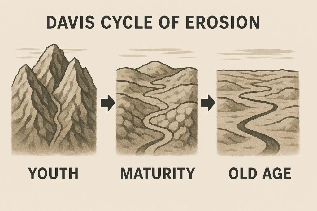
Although modern geomorphology recognizes limitations of Davis’s model, particularly its assumption of stability. The concept remains important for understanding landscape evolution under ideal conditions.
Landforms Produced by Endogenic Processes
Fold Mountains
Fold mountains are formed when compressional forces cause the Earth’s crust to bend into folds. These mountains are typically associated with convergent plate boundaries and exhibit complex geological structures. The Himalayas represent a classic example of young fold mountains characterized by steep slopes, high relief, and active tectonics.
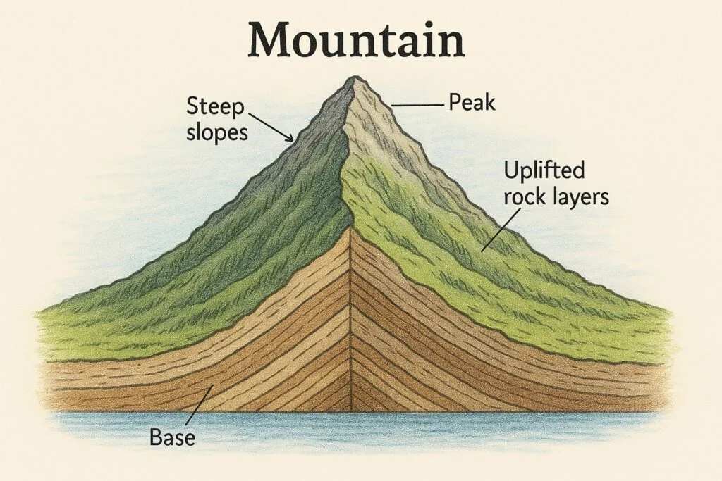
Young fold mountains are geologically unstable and prone to earthquakes and landslides. Their formation demonstrates the role of plate tectonics in creating major relief features.
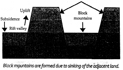
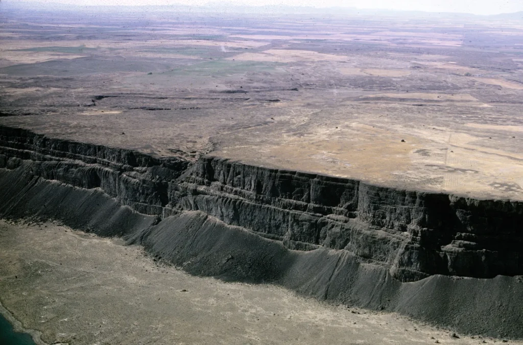
Block Mountains and Rift Valleys
Block mountains form due to faulting when large crustal blocks are uplifted or down-faulted. Upthrown blocks form horsts, while downthrown blocks form grabens or rift valleys. These features indicate tensional forces within the Earth’s crust.
Plateaus
Plateaus are elevated flat-topped landforms formed through volcanic activity, crustal uplift, or erosion of surrounding regions. The Deccan Plateau originated primarily through extensive volcanic lava flows, illustrating how volcanism contributes to landscape formation.
Plateaus often serve as important mineral and resource regions because of their geological stability and rock composition.
Landforms Produced by Fluvial Processes
Running water is one of the most powerful agents of erosion and deposition. River action creates a variety of erosional and depositional landforms depending on gradient, discharge, and sediment load.
In the upper course of a river, vertical erosion dominates, producing V-shaped valleys, gorges, and waterfalls. As the river enters its middle course, lateral erosion widens valleys and produces meanders. In the lower course, deposition dominates, forming floodplains, levees, and deltas.
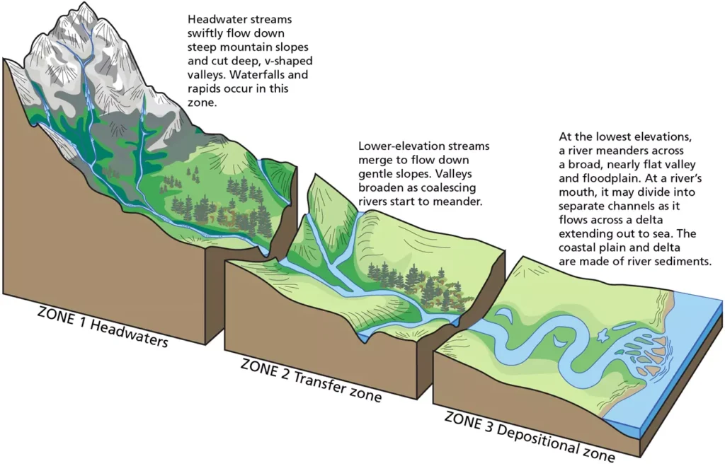
The alluvial plains of the Ganga represent one of the most extensive depositional landforms formed through long-term sediment accumulation. These plains support dense population due to fertile soils and water availability.
Fluvial landforms illustrate how erosion and deposition operate simultaneously within a drainage system.
Glacial Landforms
Glaciers act as powerful agents of erosion in high-latitude and high-altitude regions. Moving ice erodes bedrock through plucking and abrasion, creating characteristic features such as cirques, arêtes, horns, and U-shaped valleys.
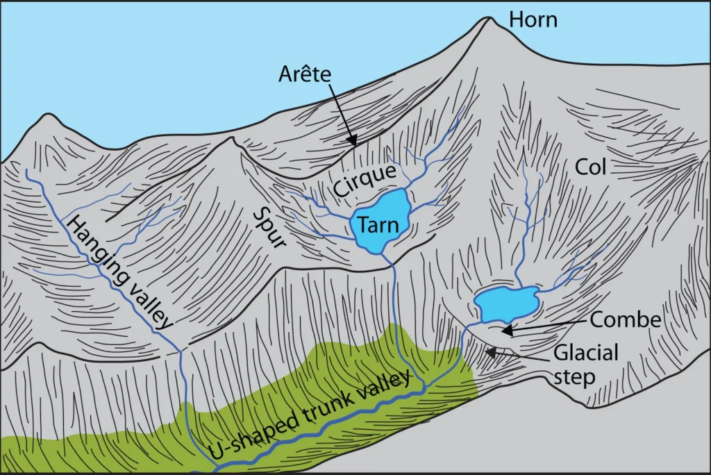
Depositional features include moraines, drumlins, and outwash plains. Glacial action demonstrates how climate plays a crucial role in shaping landscapes. Regions formerly covered by ice sheets show clear evidence of glacial modification even after ice retreat.
Aeolian Landforms
Wind action becomes significant in arid and semi-arid regions where vegetation cover is minimal. Wind erodes surfaces through deflation and abrasion and deposits materials to form dunes and loess deposits.
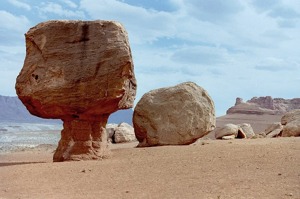
Desert landforms such as mushroom rocks, yardangs, and sand dunes demonstrate how climatic conditions influence geomorphic processes. Wind-shaped landscapes indicate the importance of atmospheric processes in landform development.
Marine Landforms
Sea waves continuously reshape coastlines through erosion, transportation, and deposition. Erosional features include sea cliffs, wave-cut platforms, caves, arches, and stacks. Depositional features include beaches, spits, and bars.
Coastal geomorphology reflects the interaction between sea level changes, wave energy, and geological structure. These processes are particularly relevant for understanding coastal vulnerability and climate change impacts.
Role of Structure, Climate, and Time
- Landform development is controlled not only by geomorphic processes but also by geological structure, climate, and duration of exposure.
- Geological structure determines rock resistance and direction of erosion. Hard rocks form ridges, while softer rocks form valleys.
- Climate influences the dominance of geomorphic agents. Humid climates favour fluvial processes, arid climates favour wind action, and cold climates favour glacial processes.
- Time determines the stage of landscape evolution. Longer exposure allows greater denudation and landscape leveling.
Significance of Landform Development
Understanding landforms has practical significance for environmental planning, disaster management, and resource utilization. Mountain regions are prone to landslides and earthquakes, river plains face flood risks, and coastal regions are vulnerable to erosion and sea-level rise.
Landforms also influence agriculture, biodiversity distribution, and settlement patterns. For instance, fertile alluvial plains support intensive farming, while plateau regions are rich in minerals.
Conclusion
Landforms are the result of continuous interaction between internal tectonic forces and external denudational processes operating over geological time. Their development reflects the dynamic nature of the Earth’s surface shaped by structure, climate, and geomorphic processes. From towering mountains to vast plains and coastal features, each landform represents a stage in the ongoing evolution of the Earth’s crust.
FAQs
Q1. What are landforms in geomorphology?
Landforms are natural physical features of the Earth’s surface formed through internal (endogenic) and external (exogenic) geomorphic processes.
Q2. How do landforms evolve over time?
They evolve through a continuous interaction of tectonic uplift, volcanic activity, weathering, erosion, transportation, and deposition.
Q3. What is the role of endogenic forces in landform development?
Endogenic forces originating within the Earth create primary relief features such as mountains, plateaus, and basins through tectonism and volcanism.
Q4. How do exogenic processes modify landforms?
Exogenic processes driven by solar energy and climate reshape existing relief through weathering, erosion, mass wasting, and deposition.
Q5. What is the cycle of erosion?
It is a conceptual model explaining the sequential development of landscapes through stages such as youth, maturity, and old age under denudational processes.