Jet Streams and Air Masses UPSC
Content
- Introduction
- Jet Streams
- Formation of Jet Streams
- Characteristics of Jet Streams
- Types of Jet Streams
- Jet Streams and Weather Systems
- Air Masses
- Classification of Air Masses
- Fronts
- Conclusion
- FAQs
Introduction
The Earth’s atmospheric system is governed by large-scale circulation patterns that regulate weather and climate across regions. Among these, jet streams and air masses play a central role in shaping atmospheric dynamics. While jet streams operate in the upper atmosphere as high-speed wind currents influencing large-scale weather systems, air masses represent vast bodies of air with uniform characteristics that determine local weather conditions. Their interaction forms the basis of meteorological processes such as cyclones, fronts, and monsoons.
Jet Streams
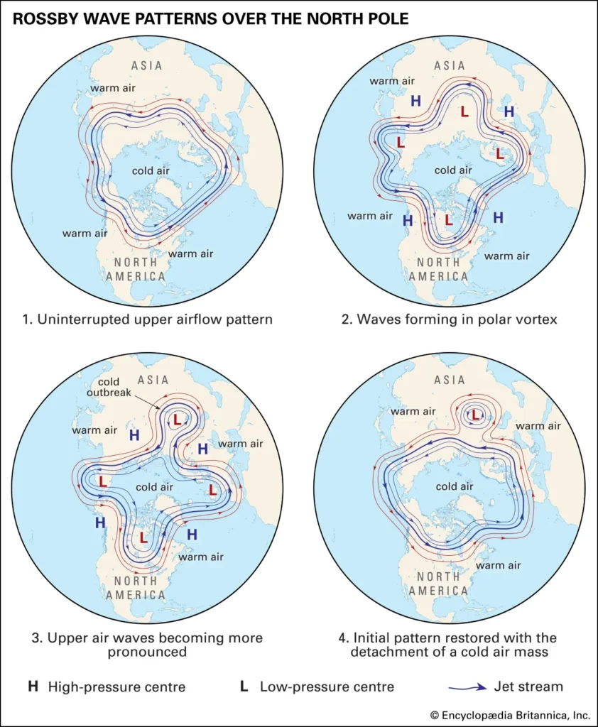
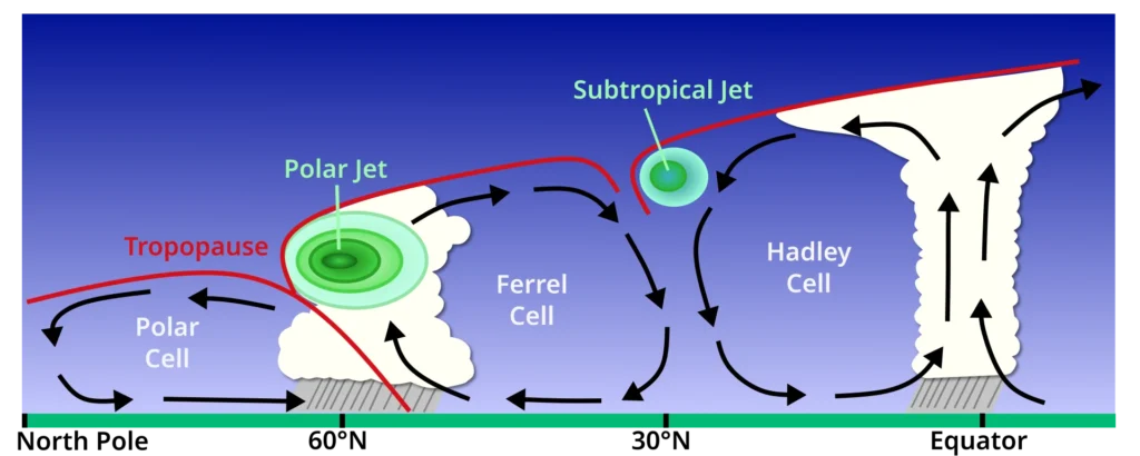
Jet streams are narrow bands of fast-flowing winds located in the upper troposphere and lower stratosphere, typically at altitudes of 9 to 16 kilometres. These winds generally flow from west to east due to pressure gradients and the Coriolis force. They are not straight but follow a wavy pattern known as Rossby waves, which play a crucial role in the development of weather systems.
Jet streams are circumpolar in nature, encircling the Earth in both hemispheres, although their paths are dynamic and continuously shifting. Their high velocity, often exceeding 300 km/h, makes them one of the most powerful atmospheric phenomena.
Formation of Jet Streams
Jet streams are primarily formed due to the unequal heating of the Earth’s surface, which creates strong temperature gradients between the equator and the poles. Warm air near the equator rises and moves poleward in the upper atmosphere, while cold air from polar regions moves equatorward. This interaction generates pressure differences, leading to the formation of high-speed winds near the tropopause.
The Coriolis force deflects these winds, resulting in a predominantly west-to-east flow. During winter, the temperature contrast between polar and tropical regions intensifies, strengthening the jet streams. Conversely, during summer, the reduced thermal gradient weakens them.
Characteristics of Jet Streams
Jet streams are characterised by high velocity, narrow width, and significant vertical and horizontal wind shear. They exhibit seasonal shifting, moving poleward in summer and equatorward in winter. Their wavy trajectory influences the movement of cyclones and anticyclones.
They are also associated with clear-air turbulence, which poses challenges to aviation. Their strength and position directly affect weather phenomena such as storms, rainfall patterns, and temperature variations.
Types of Jet Streams
1. Polar Jet Stream
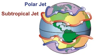
Located between 45° and 60° latitudes, the polar jet stream forms at the boundary between cold polar air and warm tropical air. It is highly variable and strongest during winter, significantly influencing mid-latitude weather systems and cyclonic activity.
2. Subtropical Jet Stream
Found near 30°-35° latitudes, the subtropical jet is relatively stable and weaker than the polar jet. It is associated with descending air and generally brings dry and stable weather conditions.
3. Tropical Easterly Jet (TEJ)
This seasonal jet develops during the Indian summer due to intense heating of the Tibetan Plateau. Unlike other jet streams, it flows from east to west and plays a critical role in strengthening the Indian monsoon.
4. Polar Night Jet
This jet forms in the stratosphere over polar regions during winter due to extreme temperature differences and influences upper atmospheric circulation.
5. Low-Level Jet Streams
These occur in the lower troposphere, with the Somali Jet being a prominent example that transports moisture towards the Indian subcontinent, aiding monsoon rainfall.
Jet Streams and Weather Systems
Role in Cyclone Formation
Jet streams play a crucial role in the development and intensification of cyclones. They create upper-level divergence, allowing surface pressure to drop and cyclones to strengthen. They also act as steering currents, guiding the movement of cyclonic systems.
Influence on Indian Monsoon
Jet streams are critical in determining the onset and intensity of the Indian monsoon. The northward shift of the subtropical westerly jet during summer allows monsoon winds to penetrate India. Simultaneously, the development of the Tropical Easterly Jet enhances rainfall. Any anomaly in their movement can lead to delayed monsoon or drought conditions.
Impact on Extreme Weather and Climate Change
Changes in jet streams due to global warming, particularly polar amplification, are making them weaker and more wavy. This results in prolonged extreme weather events such as heatwaves, floods, and cold spells due to blocking patterns.
Air Masses
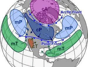
Air masses are large bodies of air with relatively uniform temperature, humidity, and pressure characteristics over a vast horizontal extent. They form over homogeneous surface regions called source regions, such as oceans, deserts, or polar areas, where they acquire specific properties.
Air masses are dynamic and move across regions, modifying local weather conditions. Their interaction leads to the formation of fronts, which are zones of transition between contrasting air masses.
Formation of Air Masses
Air masses form when air remains stationary over a large, uniform surface for an extended period. The nature of the surface determines the characteristics of the air mass. For instance, air masses formed over oceans become moist, while those formed over land are dry.
Stable atmospheric conditions, such as anticyclonic regions, favour the formation of air masses by preventing mixing and allowing uniform characteristics to develop.
Classification of Air Masses
Based on Source Region (Temperature)
Tropical (T) air masses originate in low latitudes and are warm. Polar (P) air masses develop in higher latitudes and are cold, while Arctic (A) air masses are extremely cold and originate near the poles.
Based on Surface Type (Moisture)
Continental (c) air masses form over land and are dry, whereas maritime (m) air masses form over oceans and are moist.
Combined Classification
Air masses are often classified by combining temperature and moisture characteristics. For example, continental tropical (cT) air masses are hot and dry, maritime tropical (mT) are warm and humid, continental polar (cP) are cold and dry, and maritime polar (mP) are cold and moist.
Fronts: Interaction of Air Masses
Fronts are boundaries between two contrasting air masses that do not mix easily. They are zones of intense weather activity and play a crucial role in meteorology.
Types of Fronts
A cold front forms when a cold air mass advances and forces warm air to rise rapidly, resulting in heavy rainfall and thunderstorms. A warm front occurs when warm air gradually rises over cold air, producing widespread and steady precipitation. A stationary front forms when neither air mass advances, leading to prolonged cloudy and rainy conditions. An occluded front develops when a cold front overtakes a warm front, creating complex weather patterns.
Significance of Air Masses and Fronts
Air masses and fronts are fundamental to weather formation and climate systems. They determine temperature, humidity, and precipitation patterns across regions. Fronts are responsible for most weather disturbances, including cyclones, storms, and rainfall events.
Their study is essential for weather forecasting, disaster management, agricultural planning, and understanding global climate dynamics. They also play a crucial role in the formation of temperate cyclones and influence seasonal weather patterns.
Conclusion
Jet streams and air masses together form the backbone of atmospheric circulation. While jet streams control large-scale weather patterns and guide storm systems, air masses determine regional climatic conditions and generate weather disturbances through their interaction. A comprehensive understanding of these concepts is essential for analysing global and regional climate systems, making them highly relevant for both theoretical understanding and practical applications in geography.
FAQs
Q1. What are jet streams?
Jet Streams are narrow bands of high-speed winds in the upper troposphere that generally flow from west to east and influence weather patterns.
Q2. What are the main types of jet streams?
The major types include:
Tropical Easterly Jet (over India during monsoon)
Polar Front Jet Stream
Subtropical Jet Stream
Q3. How do jet streams affect climate and weather?
They influence cyclone formation, movement of weather systems, temperature variations, and monsoon dynamics, especially in regions like India.
Q4. What are air masses?
Air Masses are large volumes of air with relatively uniform temperature and moisture characteristics acquired from their source regions.
Q5. What are source regions of air masses?
Source regions are large, uniform areas like oceans, deserts, or ice-covered regions where air masses acquire their properties.
Click on the question to see the Answers
Visit LevelUp IAS- Click Here