GS-III (Economy, S&T, Environment)
ISRO Satellites
< General Studies Home Page < Space
Content
1) BASICS
- What is a satellite?
-
- Satellite means a smaller, space-based object moving in a loop (an orbit) around a larger object.
- The Moon is a natural satellite of earth because gravity locks it in orbit around our planet.
- Satellite means a smaller, space-based object moving in a loop (an orbit) around a larger object.
- Types of Artificial Satellites
- Artificial satellites are grouped according to the jobs they do or the orbit they follow.
2) COMMUNICATION SATELLITES
- Introduction
- A communication satellite is an artificial satellite that is placed in earth’s orbit for the purpose of sending and receiving communication data between a source and destination. They are basically “space mirrors” that can help us bounce radio, TV, Internet data, and other kinds of information from one side of earth to another.
- It is used to provide data communication and relaying services for televisions, radio, telecommunication, weather and internet.
- Communication satellites essentially overcome the problem of sending radio waves, which travel in straight lines, around our curved planet.
- They commonly move in geo-stationary orbit.
- Why?
- Communication satellites can also move in highly elliptical orbit.
- Two types of Communication Satellites – Passive and Active
A) Communication satellites of India / ISRO
- The Indian National Satellite System (INSAT) System is one of the largest domestic communication satellite systems in Asia-Pacific region.
- It was established in 1983 with the launch of INSAT 1B, it initiated a major revolution in India’s communications sector and sustained the same later.
- The system presently consists of the constellation of INSAT system consisting of around 20 operational satellites, namely INSAT-3A, 3C, 4A, 4B, 4CR, GSAT 6,7,8,9,10, 12, 14, 15, 16, 18, 19, 17, 6A, 29, 11 (largest 5850 Kg, Dec 2018), 7A (Mostly for serving air force, Dec 2018) and 31 (Feb 2019).
- INSAT system with more than 200 transponders in the C, extended C and Ku-bands provides services to telecommunication, television broadcasting, satellite newsgathering, societal application, weather forecasting, disaster warning and search and rescue operations.
B) Recent Examples of Communication Satellites
- Why in news?
- ISRO’s commercial arm to launch GSAT-20 Satellite on SpaceX’s Falcon-9 in 2024 (Jan 2024)
- Details about GSAT
- The GSAT-20 is a high throughput Ka- band satellite which will be fully owned, operated and funded by NSIL.
- It will offer Ka-Ka band HTS capacity with 32 beams having Pan-India coverage including A&N and Lakshadweep.
- The satellite weighs 4,700 kg and offers HTS capacity of nearly 48 Gbps and has been specifically designed to meet the demanding service needs of remote and unconnected areas.
1) Earth Observation Satellites (Photography, Imaging and Scientific Surveying)
- Earth Observation Satellites are specifically designed for Earth Observation from Orbit and are used for environmental monitoring, meteorology, map making etc. Most earth observation satellites carry instruments that should be operated at a relatively low altitude.
- Earth Observation Satellites of India
- Starting with IRS-1A in 1988, ISRO has launched many operational remote sensing satellites.
- Today, India has one of the largest constellations of remote sensing satellites in operation. Currently, earth observation satellites which are in Sun-synchronous orbit include
- EOS-01, EOS-02, EOS-06 (Oceansat-3)
- RESOURCESAT-1, 2, 2A
- CARTOSAT-1, 2, 2A, 2B etc
- CARTOSAT-3 (Launched in Nov 2019)
- RISAT-1, RISAT-2, RISAT-2B (launched in May 2019 – PSLV C46), RISAT-2BR1 (launched in Dec 2019 – PSLV C-48)
- OCEANSAT-2
- Megha-Tropiques, SARAL and SCATSAT-1
- HySIS
- Earth Observation satellites in Geostationary Orbit include:
- EOS-03 (couldn’t be put in orbit due to failure of GSLV-F10)
- INSAT-3D, INSAT 3DR
- Kalpana & INSAT 3A
- Varieties of instruments have been flown onboard these satellites to provide necessary data in a diversified spatial, spectral and temporal resolutions to cater to different user requirements in the country and for global usage. The data from these satellites are used for several applications covering agriculture, water resources, urban planning, rural development, mineral prospecting, environment, forestry, ocean resources and disaster management
- Why in news recently?
- ISRO’s GSLV-F12 successfully places navigation satellite NVS-01 into intended orbit (May 2023)
a) Basics About SATNAV
- A satellite navigation (SATNAV) system is a technology that allows users to determine their precise location, velocity, and time information anywhere on or near Earth’s surface.
- It uses a network of satellite in space and provide accurate positioning data.
- Currently, there are four global satellite-based navigation system – the American GPS, the Russian GLONASS (GLObalnaya NAvigatsionnaya Sputnikovaya Sistema), the European Galileo and the Chinese BeiDou.
- India has a regional system called NavIC and Japan has Quasi Zenith.
- Methods used in SATNAV: Triangulation and Trilateration:
- Accuracy: They generally provide high levels of positioning accuracy (within a few meters), depending on the quality of receiver and the number of satellites in view. However, various factors such as signal obstruction, atmospheric conditions, and receiver limitations can affect the accuracy.
- Applications: Navigation purposes -> helping users find their way while driving, hiking, or boating. It is also used in aviation, surveying, geolocation-based services, precision agriculture, and even in some outdoor recreational activities. It can be used for vehicle tracking, fleet management, precise timing etc.
b) Global Positioning System (GPS)
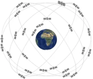
- The best-known satnav system, GPS, uses 24 active satellites (including backups). Day and night, 365 days a year, they whiz around earth once every 12 hours on orbital plane inclined 55 degrees to the equator.
- Wherever you are on earth, you are in sight of at least half a dozen of them, but you need signals from 3 or 4 satellites to determine your position with an accuracy of just a few meters.
- How GPS Finds your location?
- It uses Trilateration
- GPS Constellation arrangement
- GPS constellation fly in medium earth orbit (MEO) at an altitude of 20,200 kms. Each circle orbits the earth twice a day.
- The satellites are arranged in six equally placed orbital planes surrounding the earth. Each plain contains four slots occupied by baseline satellites. This 24-slot arrangement ensures users can view at least four satellites from virtually any point on the planet.
 c) BeiDou
- Details
- China initiated Beidou in 1994 with first BeiDou satellite launched in 2000.
- Second generation BeiDou (BDS-2) provided coverage to Asia Pacific region starting in 2012.
- Third generation BeiDou (BDS-3) satellite deployment started in 2015. In 2020, the system has been completed and it can now provide global services. With this they have joined United States’ GPS and Russia’s GLONASS in providing global PNT services, with Europe’s Galileo to follow. These are all compatible and interoperable, meaning users can draw services from all of those to improve accuracy.
- Satellite Constellation
- 24 satellites in Medium Earth Orbit (around 21,500 kms above the earth) provide the positioning, navigation, and timing (PNT) services. These satellites use rubidium and hydrogen atomic clocks for highly-accurate timing that allows precise measurement of speed and location.
- Satellites in geosynchronous Orbit (including Geo-stationary orbit) help BeiDou provide short messaging service through which 120-character messages can be sent to other BeiDou receivers.
- Plans of Expansion:
- In Nov 2022, China outlined plans to further expand the global reach of its home grown Beidou satellite navigation system.
- Pakistan in 2014 became the first foreign country to set up a Beidou network.
- Beidou has set up a first of three Continuously Operating Reference Stations (CORS) for its network in Thailand in 2013, to serve as a hub for ASEAN.
- In Nov 2022, China outlined plans to further expand the global reach of its home grown Beidou satellite navigation system.
d) GAGAN and GEMINI (class discussion)
e) NAVIC (Navigation using Indian Constellation)
- Indian Regional Navigation Satellite System (IRNSS) (also called Navigation Using Indian Constellation (NAVIC)), is a regional satnav system developed by ISRO. It aims to provide reliable position, navigation and timing (PNT) services over India and its neighbourhood, upto 1500 km from its boundary. In addition it is also capable of broadcasting messages. This can be used for broadcasting safety-of-life alerts in areas with poor or no communication, particularly in Ocean.
- Need of IRNSS when services like GPS are easily available.
- The access to foreign controlled global navigation satellite systems is not guaranteed in hostile situations, as happened to Indian military depending on American GPS during Kargil Wa
- NAVIC provides two types of services:
- Standard Positioning Service (Open for Civilian Use)
- Restricted Services (Encrypted one, for authorized users (military))
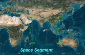
- Components of IRNSS System:
- Space segments consists of 7 satellites, 3 satellites in GEO stationary orbit (GEO) and 4 satellites in GEO synchronous orbit(GSO) with inclination of 29 degree to the equatorial plane.
- All the satellites will always be visible in the Indian region.
- First of the 2nd generation satellite – NVS-01 was successfully launched in May 2023
- ISRO’s GSLV F12 (GSLV-MK-II mission)successfully places navigation satellite NVS-01 into intended orbit.
- About GSLV F12:
- It is the 15th flight of India’s GSLV and the 9th flight with indigenous cryo stage.
- About NVS-01:
- Heavier: It weighs 2232 kg and has been placed in geosynchronous orbit (older IRNSS satellites weighed 1,425 kg)
- Indigenous Atomic Clock: For the first time, the satellite carries an indigenous atomic clock. The space qualified Rubidium atomic clock has been indigenously developed by Space Application Centre – Ahmedabad.
- L1 signals for better use in wearable devices: The second generation satellites have send signals in a third frequency, L1, besides the L5 and S frequency signals that the existing satellites provide. This will increase operability with other satellite based navigation systems. L1 frequency is the most commonly used in the GPS and will increase the use of NavIC in wearable devices which use low power signal frequency chip.
- Longer Mission Life of 12 years (earlier NavIC satellites have a mission life of 10 years).
- Current Situation (June 2023)
- The receivers have now been deployed, and NavIC is in use for projects like public safety, power grid synchronization, real-time train information system, and fishermen’s safety.
- Other upcoming initiatives (such as) common alert protocol based emergency warning, time dissemination, geodetic network, unmanned aerial vehicles are in the process of adopting NavIC system.
- Some cell phone chipsets build by Qualcomm, MediaTek integrated NaviC receivers in 2019. Some example phones which are NavIC enabled include Redmi Note 9, realme 6, the OnePlus Nord etc.
3) Satellites to study the Sun: ADITYA L1
- It is India’s first observatory class space based solar mission.
- It was launched into space on 2nd Sep 2023 onboard PSLV-C57 and reached the L1 point on 6th Jan 2024, 127 days after its launch.
- It has a mission life of 5 years during which its payloads will study various aspects of sun. It serves as a space weather station and the data from the spacecraft will aid in making models and predicting storms in advance.
- The orbit of Aditya-L1 spacecraft is a periodic Halo Orbit with an orbital period of about 178 earth days. This halo orbit is a periodic, three dimensional orbit at L1 involving sun, earth and spacecraft.
- Why study sun from space and specifically from Lagrangian point 1?
- Why study sun from Space?
- Various types of radiations from sun are not able to reach earth due to atmosphere of the earth and earth’s magnetic field making their study difficult from earth.
- Why from Lagrangian Point-1 (L1)?
- A Satellite placed in the halo orbit around the Lagrangian point 1 (L1) of the Sun-Earth system has the major advantage of continuously viewing the Sun without any occultation/ eclipses.
- Why study sun from Space?
What Trajectory ADITYA-L1 followed to reach Lagrangian Point-1: Through various orbit raising manoeuvres and cruise phase, it was placed in a halo orbit around the Lagrangian Point-1 (L1) of the Sun Earth System, which is about 1.5 million km from the Earth.
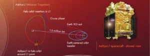
The path Aditya-L1 will take to get to L1.
- Major Science Objectives:
- Understand the coronal heating and solar wind acceleration; understand the initiation of Coronal mass ejection (CME), flares, and near earth space weather; understand the coupling and dynamics of the solar atmosphere; understand solar wind distribution and temperature anisotropy.
- Aditya-L1 went with 7 Payloads:
- Remote Sensing Payload:
- Visible Emission Line Coronagraph (VELC): It can peek as close as 05 solar radii, a region never imaged by any solar telescope. It can thus give us more information about coronal mass ejection.
- Solar Ultraviolet Imaging Telescope (SUIT): It will observe UV radiations from different zones of the solar atmosphere. It will help us to better understand the climate variation on earth.
- Solar Low Energy X-Ray Spectrometer (SoLEXS)
- High Energy L1 Orbiting X-Ray Spectrometer (HEL1OS)
- In-Situ Payloads:
- Aditya Solar Particle Experiment (ASPEX): In-situ measurements of solar particles and ions.
- Plasma Analyzer Package for Aditya (PAPA)
- Advanced Tri-axial High Resolution Digital Magnetometers
With the help of e,f, and g scientists can predict probable geomagnetic storms and better understand space weather dynamics.
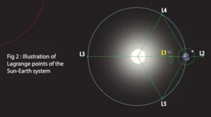
Understanding Lagrangian Points
- These are position in an orbital configuration of two large bodies where a small object affected only by gravity can maintain a stable position relative to two large bodies. The Lagrange points mark positions where the combined gravitational pull of two large masses provides precisely the centripetal force required to orbit with them.
- The interaction of the forces creates a point of equilibrium where a spacecraft may be “parked” to make observation.
- These points are named after Joseph-Louise Lagrange, an 18th-century mathematician.
- There are five such points, labeled L1 to L5 all in the orbital plane of two large bodies.
- Three of these Lagrangian points – L1, L2, and L3 – are unstable positions that lie along an imaginary straight line connecting the two larger bodies.
- Because of this instability, an object positioned at one of the three unstable Lagrange points L1, L2, and L3 – can be easily de-orbited by even weak force and they will then drift into space. Therefore, spacecraft here will need to frequently burn fuel via its thrusters, at the various moments of displacement to adjust to orbital movement frequently.
- Three of these Lagrangian points – L1, L2, and L3 – are unstable positions that lie along an imaginary straight line connecting the two larger bodies.
- The other two – L4 and L5 – are stable locations that from the apexes of two imaginary equilateral triangles with the two large celestial bodies at the vertices of each triangle. Objects stay undisturbed at L4 and L5 because of a restoring force – a force acting against any displacement – that prevents them from being nudged away from the stable point. Because of this stability, this point tends to accumulate a lot of interstellar dust and asteroids called Trojans that zip around the points. Scientists have detected various Trojans at L4 and L5 of Sun-Jupiter System, Sun-Mars System, Sun-Neptune system etc.
- They are also potential Site for Space Colonies
- Are there other space explorers at L1?
- Yes, it is already home to four robotic explorers – NASA’s Solar and Heliospheric Observatory Satellite, Deep Space Climate Observatory, Advanced Composition Explorer, and the Global Geospace Science Wind Satellite.
- In next few years, some more observatories by USA and EU will be reaching here.
About HALO Orbits: A halo orbit is a, three dimensional orbit near the L1, L2, or L3 Lagrangian point in the three body problem of orbital mechanics. Although the Lagrange point is just a point in empty space, its peculiar characteristics is that it can be orbited.
2) Other Important Projects of ISRO
1) Project NETRA
- It is an EWS in space to detect debris and other hazards to satellite. It will also provide warning against missile and space attack against India’s assets.
- It will consist of many observational facilities, connected radars, telescopes, data processing units, control centers etc.
- Initially, it will be launched for LEO satellites which inhabits remote sensing satellites. Eventually, NETRA will also have the capability to capture GEO, where communication satellites mostly reside.
- Does India not have any collision avoidance detection mechanism now?
- Even now, India does collision avoidance maneuvers on our satellites. But for this it depends on data from NORAD (North American Aerospace Defense Command) and others available in the public domain.
- NOTE: NORAD is an initiative of USA and Canada and shares selective debris data with many countries
2) Mission Shakti
- An ASAT tested by India.
3) Gaganyaan
4) XPOSAT (X-RAY Polarimeter Satellite)
- Why in news?
- ISRO launched the XPoSat, in a two-part mission, onboard a PSLV C58 flight on 1st Jan 2024.
- More Details
- XPoSat is a specialized science mission that will study the polarization of X-Rays in space.
- The mechanization of polarization of radiation gives away the nature of its source, including the strength and distribution of the magnetic field and the nature of radiation around it.
- XPoSat is a specialized science mission that will study the polarization of X-Rays in space.
- XPoSAT carries two scientific payloads in a low earth orbit:
- The Primary Payload (POLIX) (Polarimeter Instrument of X-Rays) will measure the polarimetry parameters (degree and angle of polarization) in medium X-ray range of 8-30 Kilo electron volt (KeV) photons of astronomical origin.
- The POLIX payload is developed by the Raman Research Institute (RRI), Bangalore, with support from ISRO centres.
- The XSPECT (X-Ray Spectroscopy and Timing): It will study X-rays of energy 8-15 KeV and changes in continuous X-Ray emissions.
- The XSPECT payload is developed by the UR Rao Satellite Centre (URSC), ISRO.
- Together (POLIX and XSPECT), they are expected to shed light on intense X-ray sources such as pulsars and blackholes.
- The Primary Payload (POLIX) (Polarimeter Instrument of X-Rays) will measure the polarimetry parameters (degree and angle of polarization) in medium X-ray range of 8-30 Kilo electron volt (KeV) photons of astronomical origin.
- Need:
- Better understanding of the universe:
- So far, astronomers have largely used and depended on spectroscopic, imaging and timing-based data obtained from either ground-based telescopes or satellite based missions. Polarization based study was done either in the optical or radio bands.
- XPOSAT will be game changer and will facilitate X-Ray polarization measurement possible from bright source, that too in the medium energy band (8-30 KeV) – which has never been attempted before.
- It is thus an excellent diagnostic tool to understand the emission processes from astronomical sources.
- In space, X-Rays get polarized by multiple factors – for e.g. when X-rays are subjected to strong magnetic field or due to interactions with material present around black holes. So, by studying this polarization, scientists can understand the key characteristics of the source.
- Better understanding of the universe:
- International Trend in Space-Based X-Ray Polarimetry
- Internationally, space-based x-ray polarimetry is gaining importance.
- The Imaging X-Ray Polarimetry Explorer (IXPE) mission, launched in 2021, represents NASA’s inaugural space-based endeavor, focused on scrutinizing X-Ray Polarization across various celestial bodies.
- Note: XPoSAT energy range of 8-30 keV for polarization measurement is complimentary to IXPE energy range of 2-8 KeV (soft X-Ray band). Therefore, XPoSat and IXPE spacecrafts will collectively probe different emission mechanisms and physics for bright X-Ray sources. Their coordinated observation will provide a wide window in the energy range of 2-30 KeV for polarimetric observations for bright X-Ray sources.
- Note: India’s ASTROSAT – India’s first astronomy-based space mission launched in Sep 2015 – performed timing and broadband spectroscopy of X-Ray sources but no polarization studies were performed.
- Internationally, space-based x-ray polarimetry is gaining importance.
- Which sources will be observed?
- The XPoSat team has identified several tens of sources radiating X-Rays. XPoSat will observe two kinds of sources – Persistent Sources (targeted known source) and transient sources (pulsars, active galactic nuclei, magnetars)
- Other Facts about XPOSAT:
- Launched on Jan 1, 2024
- Precise Circular Orbit of 650 km, inclination of 6 degrees.
- It is only the second space-based experiment, to study X-ray polarization, and at higher x-ray energies than the other, NASA’s Imaging X-Ray Polarimetry explorer.
- The instrument is totally indigenous in design and fabrication.
A) Understanding Polarization
B) Understanding Polarized Glasses
Polarized glasses cut the hazardous glare off the flat surfaces such as water, glass, and asphalt. When the polarized axis is vertical, all light that has been polarized through reflection and is now traveling horizontally (such as glare off of water or a windshield), will be blocked by the filter.
Polarized glasses are special materials which allow only vertically altering electric fields, and helps to decrease the glare from ground reflection, which consist of mostly horizontal polarization. Reflection polarizes the randomly varying sunlight into a single direction. Scattering of sunlight by air molecules also has a similar effect.
5) NASA-ISRO Synthetic APerture Radar (NISAR) Imaging Satellite
- Introduction:
- NASA-ISRO SAR (NISAR) is a LEO observatory being jointly developed by NASA and ISRO. It will map the entire globe in 12 days and provide spatially and temporally consistent data.
- It carries L and S dual band SAR, which works with sweep SAR technique to achieve large swath with high resolution data.
- Once launched, it will be world’s most expensive earth-imaging satellite till date costing around $1.5 billion.
- Collaboration
- NISAR is considered the first big collaboration between ISRO and NASA, certainly on RADAR but just in general as well.
- S-Band SAR is being built by ISRO and L-band by NASA
- The satellite will be launched from India using GSLV-MK-2.
- Uses: NISAR will provide an unprecedented, detailed view of the earth by using Advanced RADAR imaging. It is designed to observe and take measurements of some of the planet’s most complex process, including ecosystem disturbances, ice-sheet collapse, and natural hazards such as earthquakes, tsunamis, volcanoes, and landslides. The satellite thus will be used for:
- Mapping and monitoring of natural resources
- Estimating agricultural biomass over full duration of crop cycle.
- Assessing soil moisture
- Monitoring of floods and oil slicks
- Monitoring coastal erosion, coastline changes, and variation in the wind.
- Target: The target launch readiness date is January 2024.
- NISAR is considered the first big collaboration between ISRO and NASA, certainly on RADAR but just in general as well.
Related reads.
Daily Current Affairs & Important Editorials
25 Apr 2026 3 min
Environment & Ecology Module for Prelims 2026
25 Apr 2026 9 min
PSIR Optional Foundation Batch 2027
25 Apr 2026 9 min
Strategy For Political Science & International Relation (PSIR)
25 Apr 2026 1 min
Government Bidget Economic Survey
25 Apr 2026 1 min
Question of the Day – Secret sitting in house
24 Apr 2026 3 min
Put it into practice
Reading is step one.
Turn what you've just read into exam-ready answers with mentor-led practice and our structured test series.