
GS-I (History, Geography, Society)
Coastal Landforms
Introduction
The coastline is one of the most dynamic environments on the Earth's surface. It is a zone where land, sea and atmosphere continuously interact, and even apparently stable coastlines are gradually modified by waves, tides, currents, wind and changes in sea level. Unlike many landforms that develop over long geological periods, coastal features can sometimes change noticeably within a few years or even during a single storm.
Processes Responsible for Coastal Landforms
Waves are among the most important agents shaping the coast. As waves approach shallow water, their movement slows, their wavelength decreases and their height may increase before they break near the shore. The repeated impact of breaking waves gradually modifies coastal rocks and transports sediments.
Marine Erosion
Coastal erosion occurs through several processes:
- Hydraulic action: The force of waves compresses air and water into cracks and joints in rocks. Repeated pressure can widen these cracks and weaken the rock.
- Abrasion or Corrasion: Rock fragments carried by waves strike and scrape the coastline, gradually wearing it away.
- Attrition: Sedimentary particles carried by waves collide with one another, becoming smaller and more rounded.
- Solution or Corrosion: Seawater can chemically dissolve soluble rocks such as limestone.
The relative importance of these processes depends on the nature of the rock and the energy of the waves. Hard and resistant rocks tend to form steep coastal features, while weaker rocks are eroded more rapidly.
Transportation and Deposition
Waves also transport sediments along the coastline. When waves approach the shore at an angle, the swash carries sediment diagonally up the beach, while the backwash moves it more directly downslope under gravity. This produces a zig-zag movement known as longshore drift, which can transport sediment considerable distances along the coast.
Where wave energy decreases, transported sediments begin to accumulate. This process produces beaches, spits, bars, lagoons and other depositional features.
Erosional Coastal Landforms
Erosional landforms generally develop along exposed coastlines where wave energy is high and erosion is stronger than deposition.
Sea Cliffs
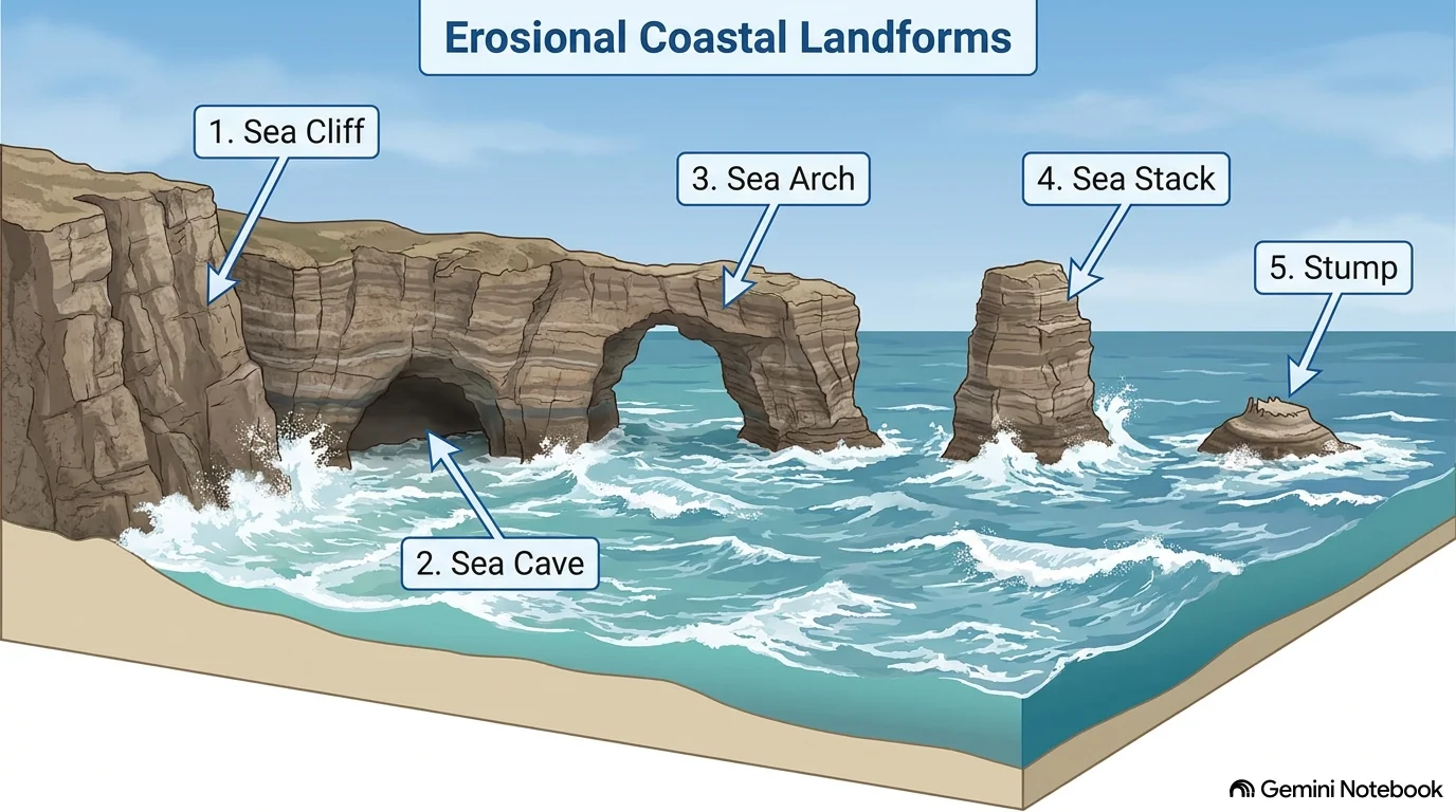
A sea cliff is a steep or near-vertical coastal slope formed by repeated wave attack at the base of the land.
Waves initially erode the weaker portions of the shoreline and create a notch at the cliff base. Continued undercutting makes the upper portion unstable, eventually causing rock material to collapse. As this process is repeated, the cliff gradually retreats inland.
Cliffs are particularly common along rocky and high-energy coastlines.
Wave-Cut Platform
As a sea cliff retreats, erosion leaves behind a relatively flat, gently sloping rocky surface at its base known as a wave-cut platform.
It is exposed during low tide and submerged during high tide. The platform provides evidence of the progressive retreat of a former coastline and is therefore useful in understanding coastal evolution.
Sea Cave
A sea cave develops when waves exploit weaknesses such as joints, fractures or softer layers in a coastal cliff or headland.
Repeated hydraulic action and abrasion enlarge these weaknesses until a hollow is formed. Where rocks have different resistance, erosion may be concentrated along particular structural lines.
Sea Arch
If erosion continues to enlarge a cave through a headland, it may eventually cut through the rock from one side to the other, producing a sea arch.
Thus, the typical sequence is:
Cracks → Cave → Arch
Sea Stack and Stump
A sea arch is not necessarily a permanent feature. Continued erosion weakens its roof, which may eventually collapse and leave an isolated pillar of rock called a sea stack.
Further erosion reduces the height of the stack, eventually producing a lower remnant known as a stump.
The sequence can therefore be represented as:
Cave → Arch → Stack → Stump
This sequence is one of the most important coastal geomorphology concepts for the UPSC examination.
Depositional Coastal Landforms
Depositional features develop where the energy of waves and currents decreases sufficiently for sediments to accumulate. They are especially common along sheltered, low-gradient and sediment-rich coastlines.
Beach
A beach is an accumulation of loose material such as sand, gravel, pebbles or shells along the shoreline.
The nature of a beach depends on sediment supply, wave energy and the type of material available. Beaches may therefore vary considerably in colour, grain size and shape.
Constructive waves, characterised by relatively strong swash and weaker backwash, generally favour deposition and beach building.
Spit
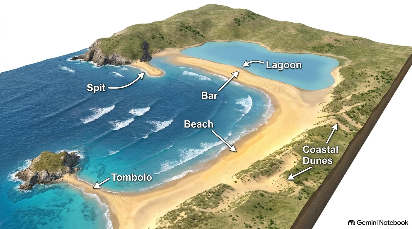
A spit is a narrow ridge of sand or shingle extending from the coastline into a sea or estuary.
It commonly develops when longshore drift transports sediment along the coast and deposition occurs where the coastline changes direction or enters a more sheltered water body.
The distal end of a spit may sometimes become curved or hooked due to changes in wave direction and currents.
Bar
A bar forms when a depositional ridge of sediment extends across the mouth of a bay or inlet.
A bar may partially or completely separate a body of water from the open sea. When such a feature develops across the entrance of a lagoon, it can contribute to the formation of a relatively enclosed coastal water body.
Tombolo
A tombolo is a depositional feature in which a ridge of sediment connects an offshore island with the mainland or another island.
Wave refraction and changes in sediment transport around the island encourage deposition in the intervening zone.
The important distinction is simple:
Spit: connected to land at one end.
Tombolo: connects an island to the mainland or another island.
Coastal Dunes
Sand dunes develop when wind transports dry beach sand inland, where vegetation or other obstacles reduce wind speed and allow sand to accumulate.
Dunes can act as natural barriers against storm surges and coastal flooding. However, excessive human disturbance and vegetation removal can make them vulnerable to erosion.
Coastal Lagoons and Estuaries
Coastal water bodies also reflect the interaction between marine and fluvial processes.
A lagoon is a relatively shallow water body separated from the open sea by a barrier, sandbar, spit or similar depositional feature. Lagoons may contain brackish water where freshwater and seawater mix.
India provides several examples, including Chilika Lake in Odisha, which lies near the coast and is separated from the Bay of Bengal by a barrier system. Chilika is as an important feature of India's eastern coast.
An estuary, in contrast, is a partially enclosed coastal water body where river freshwater mixes with seawater. Estuaries are strongly influenced by tides and are generally important zones of sediment transport and biological productivity.
Thus, while both lagoons and estuaries represent transitional coastal environments, their formation processes are different.
Rocky and Depositional Coasts: A Simple Comparison
Feature | Erosional Coast | Depositional Coast |
| Dominant process | Erosion | Deposition |
| Wave energy | Generally high | Generally lower |
| Coastline | Often steep and rocky | Often low and gently sloping |
| Sediment supply | Relatively limited | Relatively abundant |
| Major features | Cliffs, caves, arches, stacks, platforms | Beaches, spits, bars, tombolos, dunes |
| Typical setting | Exposed coastlines | Sheltered or sediment-rich coastlines |
In reality, the same coastline may contain both erosional and depositional features because wave energy and sediment movement vary from one location to another.
Factors Controlling Coastal Landforms
The shape of a coastline cannot be explained by waves alone. Several factors work together.
Rock type and geological structure determine how easily a coastline can be eroded. Resistant rocks tend to form headlands, while weaker rocks may be eroded into bays.
Wave energy determines the intensity of erosion and transportation. Storm waves can dramatically reshape beaches and cliffs within a short period.
Longshore drift redistributes sediment along the coast and is particularly important in the formation of spits and bars.
Tides and currents influence sediment movement and the development of estuaries, tidal flats and coastal inlets.
Sea-level changes can alter the position of the shoreline and may submerge or expose existing coastal features.
Human activities such as construction of ports, seawalls, groynes and sand mining can also disturb the natural movement of sediment and modify coastal morphology.
Coastal Landforms and India
India's long coastline provides examples of diverse coastal environments. The western coast is generally narrower, while the eastern coastal plains are broader and contain major river deltas. The eastern coast also includes important coastal water bodies such as Chilika Lake.
The contrast between India's western and eastern coasts is partly related to differences in relief, river systems, sediment supply and coastal configuration. Large rivers such as the Mahanadi, Godavari, Krishna and Kaveri have contributed to extensive deltaic formations along the eastern coast.
India's coastal geomorphology is therefore closely linked with its monsoon-driven river systems, marine processes and diverse coastal ecosystems.
Coastal Landforms and Climate Change
Climate change is adding another layer to coastal geomorphology. Sea-level rise, changing storm intensity, altered sediment supply and coastal flooding can accelerate shoreline change in vulnerable areas.
However, coastal erosion cannot always be attributed to climate change alone. Local factors such as dams reducing river sediment delivery, sand mining, construction of ports and seawalls, destruction of dunes and mangroves, and unplanned coastal development can significantly alter sediment dynamics.
This makes Integrated Coastal Zone Management (ICZM) important. Instead of treating every erosion-prone stretch separately, coastal planning needs to consider the entire system of waves, currents, sediment movement, ecosystems and human activity.
Conclusion
Coastal landforms are the visible outcome of a continuing contest between erosion, transportation and deposition. Waves attack rocky shores to create cliffs, caves, arches, stacks and wave-cut platforms, while declining wave energy and longshore drift encourage the formation of beaches, spits, bars, tombolos and dunes.
For geography, coastal landforms are important because they connect geomorphology with climate, ecosystems, human settlement and disaster management. Understanding how these features form also helps explain why coastlines are constantly changing and why sustainable coastal management must work with natural processes rather than attempting to completely control them.
FAQs
1. What are coastal landforms?
Coastal landforms are physical features formed along coastlines through the interaction of waves, tides, currents, wind and coastal erosion and deposition.
2. What are the two major types of coastal landforms?
Coastal landforms are broadly classified into:
- Erosional landforms: formed mainly through the removal of coastal material.
- Depositional landforms: formed through the accumulation of sediments.
3. What are the major erosional coastal landforms?
Important erosional landforms include:
- Sea cliffs
- Wave-cut platforms
- Sea caves
- Sea arches
- Sea stacks
- Sea stumps
- Geos
4. How is a sea cave formed?
Persistent wave action exploits cracks and weaker zones in coastal cliffs. Continued erosion enlarges these openings, eventually forming a sea cave.
5. How is a sea arch formed?
When wave erosion enlarges a sea cave and eventually cuts through a headland, an arch-like opening is formed. Further erosion can cause the arch roof to collapse, leaving a stack.
Related reads.

Medieval Indian Literature
28 Sep 2026 8 min
Ocean Currents
26 Sep 2026 7 min

Ancient Indian Literature
26 Sep 2026 6 min
Salinity Distribution in Oceans
25 Sep 2026 6 min

Folk Theatre of India
25 Sep 2026 5 min

Indian Classical Music
24 Sep 2026 7 min
Put it into practice
Reading is step one.
Turn what you've just read into exam-ready answers with mentor-led practice and our structured test series.