
GS-I (History, Geography, Society)
Cyclones, UPSC Geography
Content
- What is a Cyclone?
- Structure of a Tropical Cyclone
- Conditions Necessary for the Formation
- Mechanism of Cyclone Formation
- Classification of Cyclones
- Difference between Tropical and Extratropical Cyclones
- Cyclones in India
- Why is the Bay of Bengal More Cyclone-Prone than the Arabian Sea?
- FAQs
Cyclones are among the most powerful atmospheric disturbances occurring on Earth. They are large-scale low-pressure systems around which winds spiral inward due to pressure differences and the Coriolis force. Besides being one of the most destructive natural hazards, cyclones also perform an important climatic function by redistributing heat and moisture from tropical regions to higher latitudes, thereby maintaining the Earth's energy balance.
Understanding the formation, movement, characteristics, impacts, and management of cyclones is therefore essential from both the Prelims and Mains perspectives.
What is a Cyclone?
A cyclone is a large rotating atmospheric system surrounding a centre of low pressure in which air converges at the surface and rises vertically into the atmosphere. As the air rises, it cools and condenses, releasing latent heat that further strengthens the system.
The term Cyclone was derived from the Greek word Kyklos, meaning a circle or coil of a snake, referring to the spiral cloud bands visible in satellite imagery.
One of the defining characteristics of cyclones is the inward spiralling motion of winds. This rotation occurs because of the Coriolis force, which is produced by the rotation of the Earth. Consequently, cyclones rotate anticlockwise in the Northern Hemisphere and clockwise in the Southern Hemisphere.
Cyclones are generally associated with:
- Low atmospheric pressure
- Strong converging winds
- Thick cumulonimbus cloud formation
- Heavy rainfall
- Thunderstorms
- High-speed winds
- Storm surges in coastal regions
Pressure Systems and the Role of Coriolis Force
The Earth's atmosphere is characterised by alternating belts of high and low pressure. Air naturally moves from areas of high pressure towards areas of low pressure. However, due to the Earth's rotation, these winds do not move in a straight line but are deflected by the Coriolis force.
In a low-pressure system, surrounding air continuously converges toward the centre. Instead of flowing directly inward, the Coriolis force causes the air to spiral around the centre, producing the characteristic circular motion of a cyclone.
The strength of the Coriolis force increases with latitude and becomes negligible near the Equator. This explains why tropical cyclones rarely develop within 5° latitude north and south of the Equator, despite the presence of warm ocean waters.
Structure of a Tropical Cyclone
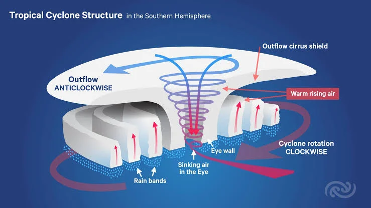
A mature tropical cyclone has a highly organised structure consisting of several distinct components. Each component plays an important role in determining the intensity and behaviour of the storm.
Eye
The eye is the central portion of the cyclone and represents the region of lowest atmospheric pressure. Contrary to popular belief, the eye is relatively calm, experiencing light winds and often clear skies. Depending on the intensity of the cyclone, the diameter of the eye generally ranges between 20 and 60 kilometres.
The formation of a well-defined eye is considered an indication of a mature and powerful tropical cyclone.
Eyewall
Surrounding the eye is the eyewall, which is the most dangerous part of the cyclone. It contains towering cumulonimbus clouds extending several kilometres into the atmosphere. The strongest winds, heaviest rainfall, and maximum destruction occur within this region.
When a cyclone makes landfall, the eyewall is primarily responsible for severe structural damage due to extremely high wind speeds and intense precipitation.
Spiral Rain Bands
Beyond the eyewall are numerous curved bands of dense clouds known as spiral rain bands. These consist of thunderstorms separated by relatively clear regions. As these rain bands move over land, they produce intermittent heavy rainfall accompanied by gusty winds.
Upper-Level Outflow
At higher altitudes, the air rising from the cyclone diverges outward. This upper-level outflow removes accumulated air from the centre, allowing more air to rise continuously from below. Without efficient upper-level divergence, a cyclone cannot intensify.
Conditions Necessary for the Formation of Tropical Cyclones
The development of a tropical cyclone requires a rare combination of favourable oceanic and atmospheric conditions. If even one of these conditions is absent, cyclone formation becomes difficult.
The most important prerequisite is a warm ocean surface, with sea surface temperatures generally exceeding 26.5-27°C over a considerable depth. Warm oceans provide enormous quantities of moisture through evaporation. This moisture supplies latent heat, which serves as the primary energy source for the cyclone.
The atmosphere should also possess high humidity in the lower and middle troposphere. Moist air promotes continuous condensation and cloud formation, releasing further latent heat that strengthens the storm.
Another essential condition is the presence of a pre-existing low-pressure disturbance. Cyclones do not form spontaneously; they generally evolve from weak low-pressure areas, tropical depressions, or disturbances already existing over warm ocean waters.
The Coriolis force must be sufficiently strong to initiate and sustain the rotation of winds around the low-pressure centre. Consequently, cyclone formation is almost absent near the Equator.
Equally important is the presence of low vertical wind shear, which refers to only small changes in wind speed and direction with increasing altitude. Strong wind shear disrupts the vertical alignment of the cyclone, preventing further development.
Finally, there should be upper-air divergence, which allows rising air within the cyclone to escape efficiently into the upper atmosphere. This continuous removal of air from above enables more warm moist air to rise from below, intensifying the low-pressure centre.
Mechanism of Cyclone Formation
The formation of a tropical cyclone is a gradual process involving several stages of atmospheric development.
Initially, intense solar heating warms the tropical ocean surface, causing rapid evaporation. The warm, moisture-laden air becomes lighter than the surrounding atmosphere and begins to rise. As it ascends, it cools adiabatically, leading to condensation and the formation of towering cumulonimbus clouds.
Condensation releases large amounts of latent heat into the atmosphere. This additional heat further warms the surrounding air, causing even stronger upward motion. As more air rises, the atmospheric pressure near the ocean surface decreases, creating a low-pressure area.
Air from surrounding high-pressure regions begins rushing towards this developing low-pressure centre. Owing to the Coriolis force, these incoming winds start rotating around the centre instead of moving directly inward. This organised circulation gradually intensifies into a tropical depression.
As the process continues, the release of latent heat accelerates the pressure fall, leading to stronger winds, heavier rainfall, and better organisation of cloud bands. Eventually, a distinct eye forms at the centre, surrounded by the eyewall, marking the mature stage of the cyclone.
A cyclone continues to intensify as long as it remains over warm ocean waters with abundant moisture. Once it moves over land or colder waters, the supply of heat and moisture is interrupted. Increased surface friction over land further weakens the wind circulation, causing the cyclone to lose its strength and gradually dissipate.
Classification of Cyclones
Cyclones are classified on the basis of their region of origin, source of energy, latitudinal location, and atmospheric characteristics. Although several types of cyclonic systems occur across the globe, they can broadly be grouped into tropical cyclones, extratropical (temperate) cyclones, polar cyclones, and anticyclones. Among these, tropical and extratropical cyclones are the most significant from the perspective of geography, climatology, and disaster management.
Understanding the distinction between these systems is important because each develops under different atmospheric conditions, exhibits distinct structural characteristics, and affects different parts of the world.
Tropical Cyclones
Tropical cyclones are intense low-pressure systems that develop over warm tropical and subtropical oceans, generally between 5° and 30° latitude in both hemispheres. Unlike other weather systems, they derive their energy primarily from the latent heat released during the condensation of water vapour. Consequently, they are often described as warm-core systems.
These cyclones are characterised by a well-developed eye, surrounded by an eyewall containing the strongest winds and heaviest rainfall. The entire system consists of spiral bands of cumulonimbus clouds that rotate around the low-pressure centre.
Since tropical cyclones depend upon warm ocean waters for their energy, they weaken rapidly after making landfall or moving over colder waters. This explains why coastal regions bear the maximum impact of tropical cyclones, whereas inland areas experience a gradual decline in their intensity.
Globally, tropical cyclones are known by different names depending upon the ocean basin in which they occur. They are called Hurricanes in the Atlantic Ocean and Eastern Pacific, Typhoons in the Western Pacific, Cyclones in the Indian Ocean, and Willy-Willies around Australia.
In India, tropical cyclones occur mainly during the pre-monsoon season (April-June) and the post-monsoon season (October-December), with the latter accounting for the majority of severe cyclonic storms.
Extratropical Cyclones (Temperate Cyclones)
Extratropical cyclones, also known as temperate cyclones, mid-latitude cyclones, or frontal cyclones, develop between 30° and 65° latitudes in both hemispheres. Unlike tropical cyclones, they originate over both land and sea and derive their energy from the temperature contrast between warm tropical air masses and cold polar air masses.
Their formation is closely associated with the Polar Front, where contrasting air masses meet. As these air masses interact, disturbances develop along the front, gradually intensifying into large cyclonic systems.
Unlike tropical cyclones, extratropical cyclones are cold-core systems and possess distinct warm and cold fronts. They generally cover much larger geographical areas and move from west to east under the influence of the prevailing Westerlies.
These cyclones are responsible for widespread rainfall, snowfall, thunderstorms, and strong winds across Europe, North America, southern South America, and other temperate regions.
In the Indian context, Western Disturbances represent a modified form of extratropical cyclones. Originating over the Mediterranean region, they travel eastward through West Asia before reaching northwestern India during winter, bringing rainfall to the Indo-Gangetic Plains and snowfall in the Himalayas.
Difference between Tropical and Extratropical Cyclones
Basis | Tropical Cyclones | Extratropical Cyclones |
| Region of Formation | Tropical oceans (5°-30° latitude) | Mid-latitudes (30°-65° latitude) |
| Source of Energy | Latent heat released during condensation | Horizontal temperature contrast between air masses |
| Core | Warm Core | Cold Core |
| Fronts | Absent | Warm and Cold Fronts present |
| Eye | Well-developed eye | Eye absent |
| Shape | Circular and symmetrical | Asymmetrical or comma-shaped |
| Size | Comparatively smaller | Much larger |
| Rainfall | Intense rainfall over limited area | Moderate rainfall over a large area |
| Movement | Initially westward, later poleward | West to east under Westerlies |
| Duration | Generally 5-10 days | May persist for one to two weeks |
Cyclones in India
India is among the most cyclone-prone countries in the world because of its long coastline of over 7,500 kilometres and its location between two cyclone-generating basins, the Bay of Bengal and the Arabian Sea. Every year, several tropical disturbances form over these water bodies, some of which intensify into severe cyclonic storms affecting millions of people living in coastal regions.
Although cyclones originate in both basins, their frequency, intensity, and movement differ considerably due to variations in oceanographic and atmospheric conditions. Historically, the Bay of Bengal has accounted for nearly three-fourths of all tropical cyclones affecting the Indian subcontinent, whereas the Arabian Sea has remained comparatively less active. However, recent decades have witnessed an increase in severe cyclonic storms over the Arabian Sea, largely attributed to rising sea surface temperatures associated with climate change.
Cyclones generally occur during two peak seasons in India. The pre-monsoon period (April to June) witnesses the formation of several cyclones before the onset of the southwest monsoon, while the post-monsoon period (October to December) is considered the principal cyclone season, particularly for the eastern coast. November is often regarded as the most active month for severe cyclonic storms in the North Indian Ocean.
Why is the Bay of Bengal More Cyclone-Prone than the Arabian Sea?
One of the most frequently asked questions in UPSC examinations is why the Bay of Bengal experiences significantly more cyclones than the Arabian Sea. The answer lies in the interaction of oceanographic, atmospheric, and geographical factors rather than any single reason.
The Bay of Bengal possesses comparatively higher sea surface temperatures, providing abundant heat energy necessary for cyclone formation. Moreover, several major rivers such as the Ganga, Brahmaputra, Mahanadi, Godavari, Krishna, and Irrawaddy discharge enormous quantities of freshwater into the bay. This freshwater reduces surface salinity, creating a stable layer of warm water that favours rapid evaporation and continuous supply of latent heat to developing cyclones.
Another important factor is the lower vertical wind shear over the Bay of Bengal during the cyclone seasons. Weak wind shear allows thunderstorms to remain vertically aligned, enabling cyclonic systems to intensify without disruption.
The geographical configuration of the bay also plays a crucial role. The funnel-shaped northern Bay of Bengal directs cyclonic storms towards the eastern coast of India and Bangladesh, often amplifying storm surges and increasing the destructive potential of landfalling cyclones.
In addition, remnants of tropical disturbances originating in the South China Sea and Western Pacific occasionally travel into the Bay of Bengal through Southeast Asia, providing additional seeds for cyclone development.
Collectively, these favourable atmospheric and oceanic conditions explain why the Bay of Bengal generates nearly four times as many cyclones as the Arabian Sea.
FAQs
Q1. What is a cyclone?
A Cyclone is a low-pressure weather system in which winds spiral inward toward the center. The direction of rotation depends on the hemisphere due to the Coriolis force.
Q2. What are the main types of cyclones?
The two major types are:
- Tropical Cyclones: Form over warm tropical oceans.
- Temperate (Extratropical) Cyclones: Form in the mid-latitudes due to the meeting of contrasting air masses.
Q3. What are the necessary conditions for the formation of tropical cyclones?
The essential conditions include:
- Warm ocean water (generally above 26.5°C)
- High humidity in the lower and middle troposphere
- Low vertical wind shear
- Sufficient Coriolis force (usually beyond 5° latitude)
- A pre-existing low-pressure disturbance
Q4. Why do tropical cyclones not form near the Equator?
Near the Equator, the Coriolis force is too weak to generate the rotational motion required for cyclone formation.
Q5. What are the main parts of a tropical cyclone?
A tropical cyclone consists of:
- Eye: Calm central region with the lowest pressure.
- Eyewall: Region of the strongest winds and heaviest rainfall.
- Rainbands: Spiral bands of clouds and intense precipitation.
Related reads.
Independence and Partition of India
14 Sep 2026 8 min

Revolutionary Nationalism in India
12 Sep 2026 10 min

Indian National Movement – II (1918-1929)
10 Sep 2026 10 min
Regional States of North and South India
09 Sep 2026 9 min
Wind System, UPSC Geography
08 Sep 2026 9 min

Indian National Movement (Extremists) - I (1905-1918)
07 Sep 2026 10 min
Put it into practice
Reading is step one.
Turn what you've just read into exam-ready answers with mentor-led practice and our structured test series.