
GS-I (History, Geography, Society)
Karst Topography, UPSC Geography

Content
- Introduction
- Conditions Necessary for the Development
- Process of Karst Formation
- Characteristics of Karst Topography
- Surface Karst Landforms
- Underground Karst Landforms
- Depositional Karst Landforms
- Significance of Karst Topography
- Problems Associated with Karst Regions
- Distribution of Karst Topography
- Conclusion
- FAQs
Karst topography frequently appears in geography and environmental studies due to its significance in groundwater resources, cave systems, biodiversity conservation, and disaster management. In recent years, several cave discoveries, sinkhole incidents, and groundwater-related issues across the world have renewed interest in karst landscapes. For UPSC, karst topography is an important topic under Physical Geography and Geomorphology.
Introduction
Karst Topography refers to a distinctive landscape developed primarily through the dissolution of soluble rocks such as limestone, dolomite, and gypsum by groundwater. The term "Karst" is derived from the Kras Plateau located on the border of Slovenia and Italy, where such landscapes are extensively developed.
Unlike fluvial landscapes where rivers dominate erosion, karst regions are characterized by underground drainage systems. Rainwater mixed with atmospheric and soil carbon dioxide forms weak carbonic acid, which gradually dissolves limestone over thousands of years. This process creates a unique combination of surface and underground landforms including sinkholes, caves, caverns, underground rivers, and limestone pavements.
Karst landscapes occupy nearly 15-20% of the Earth’s ice-free land area and serve as important groundwater reservoirs supporting millions of people worldwide.
Conditions Necessary for the Development of Karst Topography
Karst topography develops only under specific geological and climatic conditions.
The most important requirement is the presence of highly soluble rocks, especially limestone containing a high percentage of calcium carbonate. The limestone should be thick, dense, pure, and highly jointed so that water can penetrate easily through cracks and fissures.
Adequate rainfall is essential because water acts as the main agent of dissolution. The presence of vegetation further enhances the process by increasing carbon dioxide content in the soil, making groundwater more acidic.
A relatively deep water table also favours karst development because it allows vertical percolation of water and the formation of extensive underground drainage networks.
Process of Karst Formation
The formation of karst landforms is primarily a result of chemical weathering through the process of carbonation.
Rainwater absorbs carbon dioxide from the atmosphere and soil, producing weak carbonic acid. When this acidic water comes into contact with limestone, it reacts with calcium carbonate and converts it into soluble calcium bicarbonate.
Chemical Reaction:
CaCO₃ + H₂CO₃ → Ca(HCO₃)₂
Over long periods, this process widens joints, bedding planes, and fractures within the limestone. Small cracks gradually enlarge into fissures, channels, caves, and extensive underground drainage systems. Continued dissolution and roof collapse create many characteristic karst features.
Characteristics of Karst Topography
Karst landscapes possess several distinctive features that differentiate them from other geomorphic regions.
The surface is generally rocky and barren with thin soil cover. Surface streams are either absent or poorly developed because most rainfall infiltrates underground through joints and fissures. As a result, underground rivers and drainage channels dominate the hydrological system.
The landscape contains numerous depressions, sinkholes, caves, caverns, and springs. Groundwater movement plays a much greater role than surface runoff in shaping the terrain.
Surface Karst Landforms
Lapies (Karren)
Lapies are small grooves, furrows, ridges, and channels formed on exposed limestone surfaces due to differential dissolution. Rainwater flowing along cracks gradually enlarges them, producing a rugged and uneven surface.
Lapies represent the earliest stage of karst development and are common in exposed limestone plateaus.
Limestone Pavement
A limestone pavement consists of a flat limestone surface divided into blocks known as clints separated by deep fissures called grikes.
Grikes develop through solution along joints, while clints remain as residual limestone blocks. Limestone pavements are common in regions where glacial action has removed the soil cover exposing bare limestone.
Sinkholes or Dolines
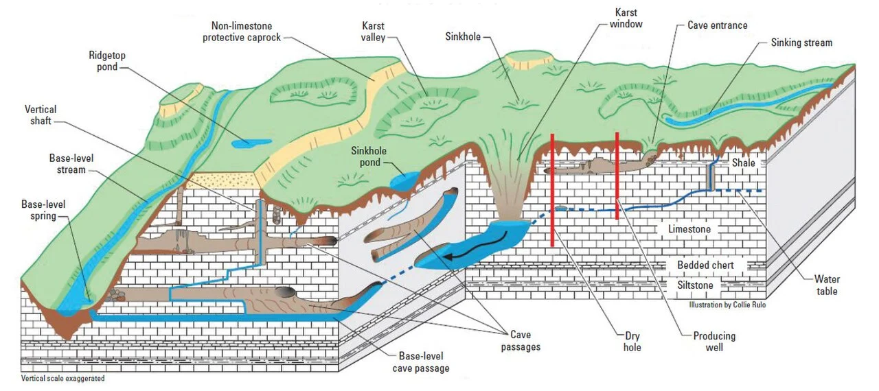
Sinkholes are circular or funnel-shaped depressions formed by the dissolution of limestone or the collapse of underground cave roofs.
They vary greatly in size and may range from a few metres to several hundred metres in diameter. Sinkholes are among the most common features of karst landscapes.
Swallow Holes
Swallow holes are openings through which streams disappear underground. Water entering these holes joins subterranean drainage systems and may reappear elsewhere as springs.
They are particularly common where rivers encounter limestone terrain.
Uvalas
When several adjacent dolines merge due to continued dissolution, they form larger irregular depressions known as uvalas.
These represent an advanced stage in karst landscape evolution.
Poljes
Poljes are the largest closed depressions found in karst regions. They are extensive flat-floored basins surrounded by steep limestone walls.
These depressions may cover hundreds of square kilometres and often become seasonally flooded due to poor drainage. Poljes are particularly well developed in the Dinaric Karst region of the Balkans.
Blind Valleys
A blind valley is a valley that abruptly terminates where a stream disappears underground through a swallow hole.
Unlike normal river valleys, blind valleys lack a surface outlet.
Underground Karst Landforms
Caves and Caverns
Caves are natural underground chambers formed by the dissolution of limestone. Continuous groundwater action enlarges these cavities into extensive cave systems.
Large caves are often referred to as caverns. Some cave systems extend for hundreds of kilometres and contain underground rivers, chambers, and passages.
Karst Windows (Fensters)
A karst window is formed when the roof of an underground cave collapses, exposing part of the subterranean stream to the surface.
These features provide a direct view of underground drainage channels.
Depositional Karst Landforms (Speleothems)
While dissolution creates caves, deposition occurs when dissolved calcium carbonate is re-precipitated inside caves.
Stalactites
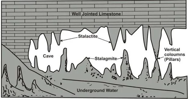
Stalactites are icicle-shaped deposits hanging from cave ceilings. They form when mineral-rich water drips from the roof and leaves behind calcium carbonate.
Mnemonic: Stalactites hang "tight" from the ceiling.
Stalagmites
Stalagmites are upward-growing deposits formed on cave floors due to the accumulation of minerals from dripping water.
They are generally thicker and more rounded than stalactites.
Pillars or Columns
When stalactites and stalagmites grow sufficiently and join together, they form pillars or columns extending from the floor to the ceiling.
Travertine and Tufa
Travertine and tufa are deposits of calcium carbonate formed around springs, waterfalls, and river channels where groundwater emerges at the surface.
Significance of Karst Topography
Karst regions possess immense geographical, ecological, and economic significance.
They serve as major groundwater reservoirs and provide drinking water to nearly one-fourth of the global population. Limestone extracted from karst areas is an important raw material for cement, construction, and chemical industries.
Karst caves preserve archaeological remains, prehistoric artefacts, and palaeoclimatic records. These landscapes also support unique ecosystems with many endemic species.
Additionally, spectacular cave systems and limestone formations contribute significantly to tourism and local economies.
Problems Associated with Karst Regions
Despite their importance, karst landscapes face several challenges. Thin soils often limit agricultural productivity. Groundwater contamination spreads rapidly because pollutants can move quickly through underground channels without natural filtration.
Sinkhole collapse poses serious risks to infrastructure, settlements, and transportation networks. Excessive groundwater extraction may also accelerate subsidence and environmental degradation.
Distribution of Karst Topography
Karst landscapes are widely distributed across the world.
Major examples include the Dinaric Karst of Slovenia and Croatia, South China Karst, Yucatán Peninsula of Mexico, Kentucky and Florida in the United States, Burren region of Ireland, and Ha Long Bay in Vietnam.

In India, important karst regions occur in the Vindhyan limestone belt, Bastar Plateau, Kashmir Himalayas, Himachal Pradesh, and parts of Andhra Pradesh. The famous Borra Caves in Andhra Pradesh are among the finest examples of karst topography in India.
Conclusion
Karst topography represents one of the most fascinating examples of landscapes shaped by chemical weathering and groundwater action. Characterized by sinkholes, caves, underground rivers, and spectacular depositional formations, karst regions demonstrate the powerful interaction between geology, hydrology, and climate.
FAQs
Q1. What is Karst Topography?
Karst Topography is a type of landscape developed by the chemical weathering and dissolution of soluble rocks, primarily limestone, resulting in distinctive surface and underground landforms.
Q2. How is Karst Topography formed?
Karst topography develops when slightly acidic rainwater containing dissolved carbon dioxide reacts with limestone, gradually dissolving the rock and creating underground drainage systems and unique landforms.
Q3. Which rocks are most suitable for the development of Karst Topography?
Karst landscapes mainly develop on:
- Limestone (most common)
- Dolomite
- Chalk
- Gypsum (in some regions)
Q4. What are the necessary conditions for the formation of Karst Topography?
The essential conditions include:
- Thick deposits of soluble rocks
- Abundant rainfall
- Presence of joints and fractures in rocks
- Well-developed groundwater circulation
- Carbon dioxide-rich water
Q5. What are the major surface landforms of Karst Topography?
Important surface features include:
- Sinkholes (Dolines)
- Uvalas
- Poljes
- Limestone pavements
- Swallow holes
- Dry valleys
Related reads.

Independence and Partition of India
14 Sep 2026 8 min

Revolutionary Nationalism in India
12 Sep 2026 10 min

Indian National Movement – II (1918-1929)
10 Sep 2026 10 min

Regional States of North and South India
09 Sep 2026 9 min

Wind System, UPSC Geography
08 Sep 2026 9 min

Indian National Movement (Extremists) - I (1905-1918)
07 Sep 2026 10 min
Put it into practice
Reading is step one.
Turn what you've just read into exam-ready answers with mentor-led practice and our structured test series.