
GS-I (History, Geography, Society)
La Niña, Climatology

Introduction
La Niña is a naturally occurring ocean-atmosphere phenomenon that forms an integral part of the El Niño-Southern Oscillation (ENSO), one of the most influential climate systems on Earth. It is characterised by an abnormal cooling of sea surface temperatures in the central and eastern equatorial Pacific Ocean, accompanied by significant changes in atmospheric circulation. While El Niño represents the warm phase of ENSO, La Niña is its cool counterpart.
Although the phenomenon originates in the Pacific Ocean, its influence extends far beyond the region, affecting rainfall, temperature, agriculture, fisheries, tropical cyclones, and monsoon systems across the globe. For India, La Niña holds particular importance because it generally strengthens the southwest monsoon, making it one of the key climatic factors influencing agricultural production, water availability, and disaster management. Understanding La Niña is therefore essential from the perspective of Physical Geography, Climatology, Environment, Agriculture, and Disaster Management.
What is La Niña?
La Niña is a climatic phenomenon in which the sea surface temperature (SST) over the central and eastern equatorial Pacific Ocean becomes significantly cooler than the long-term average for a sustained period. This cooling alters the interaction between the ocean and the atmosphere, leading to large-scale changes in global weather patterns.
Normally, easterly trade winds blow from South America towards Indonesia, pushing warm surface waters westward. During La Niña, these trade winds become stronger than usual, causing an even greater accumulation of warm water in the western Pacific while promoting the upwelling of cold, nutrient-rich water along the western coast of South America. As a result, atmospheric pressure patterns also change, strengthening the Walker Circulation and modifying rainfall distribution across the tropics.
La Niña events generally occur every 2-7 years and usually last between 9 months and one year, although strong episodes may continue for nearly two years.
Mechanism and Formation of La Niña
The development of La Niña is the result of a close interaction between the Pacific Ocean and the atmosphere.
The process begins with an unusual strengthening of the easterly trade winds across the equatorial Pacific. These stronger winds push a larger volume of warm surface water towards the western Pacific Ocean, particularly around Indonesia, Papua New Guinea, and northern Australia. Consequently, sea levels become slightly higher in the western Pacific than in the eastern Pacific.
As warm water is displaced westward, cold water from deeper ocean layers rises to the surface along the coast of Peru and Ecuador through a process known as upwelling. This upwelled water is much colder and richer in nutrients, leading to a substantial fall in sea surface temperatures across the eastern Pacific.
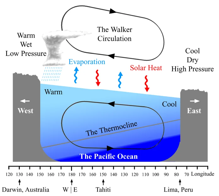
The cooler ocean surface reduces evaporation and cloud formation over the eastern Pacific while increasing convection and rainfall over the western Pacific. This further strengthens the Walker Circulation, creating a positive feedback mechanism that sustains La Niña conditions for several months.
Thus, La Niña represents a self-reinforcing interaction between ocean temperatures, atmospheric pressure, and wind circulation.
Characteristics of La Niña
La Niña exhibits several distinctive climatic characteristics that differentiate it from normal conditions and from El Niño.
The most important feature is the abnormal cooling of sea surface temperatures in the central and eastern equatorial Pacific Ocean. Simultaneously, the western Pacific becomes relatively warmer, enhancing convection and cloud formation over Southeast Asia and northern Australia.
Trade winds become much stronger than their climatological average, intensifying the movement of warm water towards the western Pacific. The Walker Circulation also strengthens considerably, producing rising air over Indonesia and descending air over the eastern Pacific.
La Niña generally brings above-normal rainfall to the western Pacific region, while causing drier conditions along the western coast of South America. It also modifies global jet streams, influencing weather systems over distant regions.
Unlike individual storms, La Niña is a slow-developing climatic event whose effects may persist for nearly one to two years.
Global Impacts of La Niña
Although La Niña develops in the Pacific Ocean, its climatic influence extends across almost every continent.
In Asia, particularly South and Southeast Asia, La Niña generally leads to stronger monsoon circulation and above-normal rainfall. Countries such as India, Bangladesh, Indonesia, Malaysia, and the Philippines frequently experience wetter conditions, although excessive rainfall can also trigger floods and landslides.
Australia often receives significantly higher rainfall during La Niña years. While this replenishes reservoirs and supports agriculture, prolonged heavy rainfall may result in devastating floods, as witnessed during several recent La Niña episodes.
In North America, La Niña usually causes colder and wetter winters across Canada and the northwestern United States, whereas the southern United States often experiences warmer and drier conditions.
Across South America, countries such as Peru and Ecuador generally witness below-normal rainfall because of the cooling of the eastern Pacific, while northern parts of the continent may receive increased precipitation.
In Africa, the impacts vary regionally. East Africa often experiences drought conditions, whereas southern Africa may receive above-average rainfall. Such variability significantly influences agricultural production and food security across the continent.
La Niña also influences tropical cyclone activity. The reduced vertical wind shear over the Atlantic Ocean favours the formation of a greater number of hurricanes, making Atlantic hurricane seasons generally more active during La Niña years.
Impact of La Niña on India
India is among the countries most strongly influenced by La Niña because of its close relationship with the southwest monsoon.
Historically, most La Niña years have been associated with above-normal monsoon rainfall over the Indian subcontinent. Stronger monsoon winds transport larger quantities of moisture from the Arabian Sea and Bay of Bengal, increasing rainfall across many parts of the country.
Enhanced rainfall generally improves agricultural productivity by supporting kharif crops such as rice, maize, cotton, pulses, and sugarcane. Reservoirs, rivers, groundwater, and hydroelectric projects also benefit from abundant precipitation, contributing to water security and energy generation.
However, excessive rainfall may produce adverse consequences. Floods in river basins, landslides in Himalayan and Western Ghat regions, urban flooding, crop damage, and disruption of transportation networks become more frequent during strong La Niña years.
It is important to note that La Niña is not the sole determinant of India's monsoon performance. Other climatic phenomena such as the Indian Ocean Dipole (IOD), Madden-Julian Oscillation (MJO), Western Disturbances, Eurasian snow cover, and local atmospheric conditions also influence rainfall distribution.
Economic and Environmental Significance
La Niña has profound implications for economies and ecosystems around the world.
Agriculture remains the most directly affected sector. Variations in rainfall influence crop yields, irrigation requirements, and food production. While favourable rainfall can improve agricultural output in some regions, excessive precipitation or prolonged drought in others may reduce productivity and threaten food security.
Water resources are also significantly affected. Reservoir storage, groundwater recharge, river discharge, and hydroelectric power generation largely depend upon seasonal rainfall patterns influenced by La Niña.
The phenomenon also plays an important ecological role in marine ecosystems. Increased upwelling along the South American coast brings nutrient-rich water to the surface, promoting phytoplankton growth and supporting one of the world's richest fishing grounds. Consequently, fisheries in Peru and neighbouring regions often witness increased productivity during La Niña years.
Conversely, extreme rainfall events, floods, cyclones, and landslides may cause large-scale environmental degradation, biodiversity loss, soil erosion, and infrastructure damage.
Difference between El Niño and La Niña
La Niña and El Niño represent opposite phases of the ENSO cycle.
While El Niño is associated with the abnormal warming of the central and eastern Pacific Ocean, La Niña involves abnormal cooling of these waters. During El Niño, trade winds weaken, whereas during La Niña they strengthen considerably.
El Niño generally suppresses the Indian southwest monsoon and increases the likelihood of drought conditions. In contrast, La Niña usually strengthens monsoon circulation, leading to above-normal rainfall over much of India.
Globally, El Niño often raises average temperatures, whereas La Niña tends to produce relatively cooler global conditions.
Conclusion
La Niña is a major component of Earth's climate system and plays a decisive role in regulating global atmospheric circulation. Although it originates in the equatorial Pacific Ocean, its influence extends to almost every continent through interconnected oceanic and atmospheric processes. For India, La Niña generally acts as a favourable factor for the southwest monsoon, strengthening agricultural production, improving water availability, and supporting economic activity. However, excessive rainfall, floods, and associated disasters also underline the need for effective forecasting, climate-resilient infrastructure, and disaster preparedness.
FAQs
Q1. What is La Niña?
La Niña is a climate phenomenon associated with the unusual cooling of sea-surface temperatures in the central and eastern equatorial Pacific Ocean. It is the cool phase of the El Niño–Southern Oscillation (ENSO) cycle.
Q2. How does La Niña develop?
During La Niña, trade winds strengthen and push warm surface water westward towards Indonesia and Australia. This allows colder, nutrient-rich water to rise toward the surface in the eastern Pacific through upwelling.
Q3. What happens to atmospheric pressure during La Niña?
La Niña strengthens the Walker Circulation, generally producing lower pressure over the western Pacific and relatively higher pressure over the eastern Pacific.
Q4. How does La Niña affect the Indian monsoon?
La Niña generally creates conditions favourable for a stronger-than-normal Southwest Monsoon over India. However, it is not the sole determinant of monsoon rainfall; other factors such as the Indian Ocean Dipole, snow cover and atmospheric circulation also matter.
Q5. What is upwelling during La Niña?
Upwelling is the process by which deeper, colder ocean water rises to the surface. During La Niña, strengthened trade winds enhance upwelling along the eastern equatorial Pacific, bringing cold, nutrient-rich water toward the surface.
Related reads.

Modern Indian Literature
29 Sep 2026 6 min

Coastal Landforms
28 Sep 2026 8 min

Medieval Indian Literature
28 Sep 2026 8 min

Ocean Currents
26 Sep 2026 7 min

Ancient Indian Literature
26 Sep 2026 6 min
Salinity Distribution in Oceans
25 Sep 2026 6 min
Put it into practice
Reading is step one.
Turn what you've just read into exam-ready answers with mentor-led practice and our structured test series.