
GS-I (History, Geography, Society)
Temperature Distribution in Oceans
Introduction
Ocean temperature refers to the degree of warmth of seawater, which varies across different latitudes, ocean basins, seasons and depths. It is an important aspect of oceanography because it influences ocean currents, marine ecosystems, atmospheric circulation, rainfall patterns and global climate.
The Sun is the principal source of heat for the oceans. However, ocean temperature is not determined by solar radiation alone. Ocean currents, prevailing winds, evaporation, water mixing, latitude and the physical configuration of ocean basins also influence its distribution.
Sources of Heat in Oceans
The oceans receive most of their heat from solar radiation (insolation). Solar energy is absorbed primarily by the upper layers of seawater, while the penetration of sunlight decreases rapidly with depth.
Ocean water also exchanges heat with the atmosphere. It loses energy through longwave radiation and evaporation, while winds and currents redistribute heat between different regions and depths. Heat from Earth's interior contributes to oceanic thermal conditions locally, particularly near hydrothermal vents, but is negligible compared with solar heating at the global scale.
Water has a high specific heat capacity, meaning that it requires considerable energy to change its temperature. Consequently, oceans heat up and cool down more slowly than land surfaces, moderating coastal climates and reducing daily temperature fluctuations.
Factors Affecting the Temperature Distribution of Oceans
1. Latitude and Insolation
Latitude is one of the most important controls on ocean surface temperature. Tropical regions generally receive more intense solar radiation because the Sun's rays strike them more directly. Towards the poles, solar radiation becomes less intense and seasonal variations in daylight become more pronounced.
Consequently, surface temperatures generally decrease from lower latitudes towards higher latitudes. However, the warmest surface waters are not always located precisely at the equator because cloud cover, rainfall, winds and ocean circulation modify the distribution of heat.
2. Ocean Currents
Ocean currents redistribute heat across the world's oceans.
Warm currents transport relatively warm water towards higher latitudes, while cold currents carry cooler water towards lower latitudes or bring cold subsurface water to the surface.
For example, the Gulf Stream warms parts of the North Atlantic, whereas the Labrador Current brings cold water southward along northeastern Canada. Their interaction produces sharp temperature contrasts near Newfoundland and influences the position of oceanic isotherms.
3. Prevailing Winds and Upwelling
Winds influence ocean temperature by moving surface water and generating vertical mixing. When winds push surface water away from a coast, colder water from below may rise to replace it. This process is known as upwelling.
Along the Peruvian coast, the prevailing trade winds promote the upwelling of cold, nutrient-rich water under normal conditions. This lowers sea-surface temperatures and supports highly productive fisheries.
Conversely, the weakening of trade winds during El Niño reduces upwelling in the eastern equatorial Pacific, allowing warmer water to spread eastward and disrupting normal ocean temperature patterns.
4. Unequal Distribution of Land and Water
The Northern and Southern Hemispheres differ in their distribution of continents and oceans. The Northern Hemisphere has a larger proportion of land, while the Southern Hemisphere is dominated by oceans at middle and high latitudes.
Continents heat up and cool down more rapidly than seawater, influencing nearby ocean temperatures through atmospheric circulation and seasonal exchanges of heat. The Southern Ocean's extensive circulation around Antarctica also affects the distribution of heat in the Southern Hemisphere.
5. Evaporation, Cloud Cover and Rainfall
Evaporation removes heat from the ocean surface because energy is required to convert liquid water into water vapour. Strong winds and dry atmospheric conditions can increase evaporation and surface heat loss.
Cloud cover influences the amount of incoming solar radiation, while rainfall can alter surface-water salinity and stratification. Heavy rainfall in equatorial regions may create a relatively fresh surface layer, affecting vertical mixing and the movement of heat.
6. Ocean Basin Configuration and Enclosed Seas
The shape, depth and degree of enclosure of an ocean basin influence water circulation and heat exchange. Semi-enclosed seas in hot, dry regions can develop high surface temperatures because of intense solar heating, high evaporation and limited exchange with the open ocean.
For example, the Red Sea and Persian Gulf experience high surface temperatures during parts of the year. However, their temperature profiles also depend on depth, water exchange and seasonal mixing.
Submarine ridges and sills may restrict the exchange of water between basins, producing differences in temperature and circulation on either side.
7. Seasonal Variations
Seasonal changes in solar radiation affect ocean temperature, particularly in temperate and polar regions. Surface waters generally warm during summer and cool during winter, although the timing and magnitude of these changes vary because of oceanic heat storage and circulation.
Tropical regions experience comparatively small annual variations in solar heating, while middle and high latitudes generally show more pronounced seasonal temperature changes.
Horizontal Distribution of Ocean Temperature
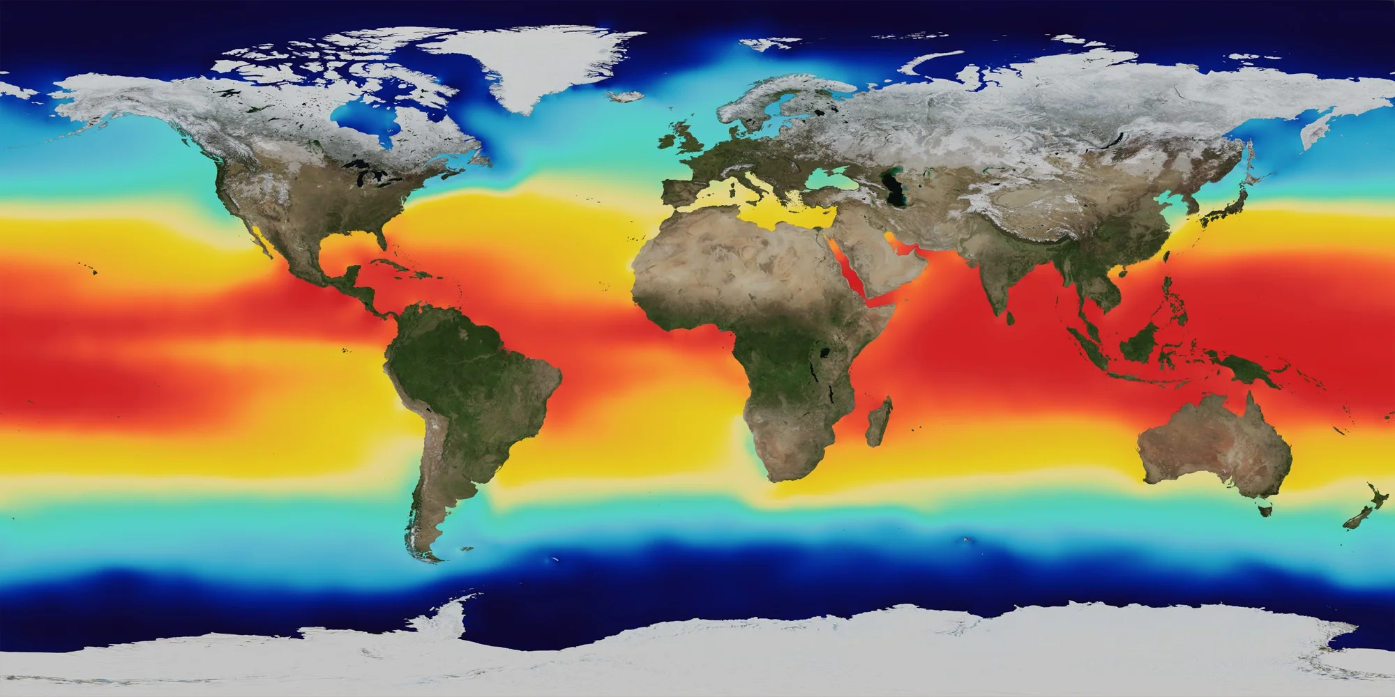
Horizontal temperature distribution refers to variations in surface-water temperature across different latitudes and ocean regions. These patterns are commonly represented by isotherms, which are lines connecting places with equal temperature.
Latitudinal Distribution
Ocean surface temperatures generally decrease from the equator towards the poles because the intensity of solar radiation decreases with increasing latitude.
However, this pattern is not perfectly uniform. Warm and cold ocean currents, prevailing winds, upwelling, cloud cover and the arrangement of continents produce regional variations.
The highest surface temperatures are generally found in tropical and subtropical waters, while polar oceans have the lowest temperatures. In some regions, the warmest waters occur slightly north or south of the equator rather than directly along it.
Distribution Between the Hemispheres
The Northern Hemisphere's ocean waters are generally warmer on average than those in the Southern Hemisphere. This broad difference reflects the unequal distribution of land and water, regional circulation patterns and the influence of the cold Southern Ocean.
The pattern varies between individual ocean basins and seasons, so hemispheric averages should not be interpreted as uniform conditions across every latitude.
Role of Isotherms
Isotherms help explain the influence of ocean currents on temperature distribution.
Where warm and cold currents meet, isotherms may be closely spaced, indicating a sharp temperature gradient. For example, the cold Labrador Current and warm Gulf Stream contribute to contrasting temperature conditions in the North Atlantic.
Warm currents can shift isotherms towards higher latitudes, while cold currents can shift them towards lower latitudes. Thus, ocean surface temperature does not follow latitude alone; it also reflects the movement of water and heat across the oceans.
Vertical Distribution of Ocean Temperature
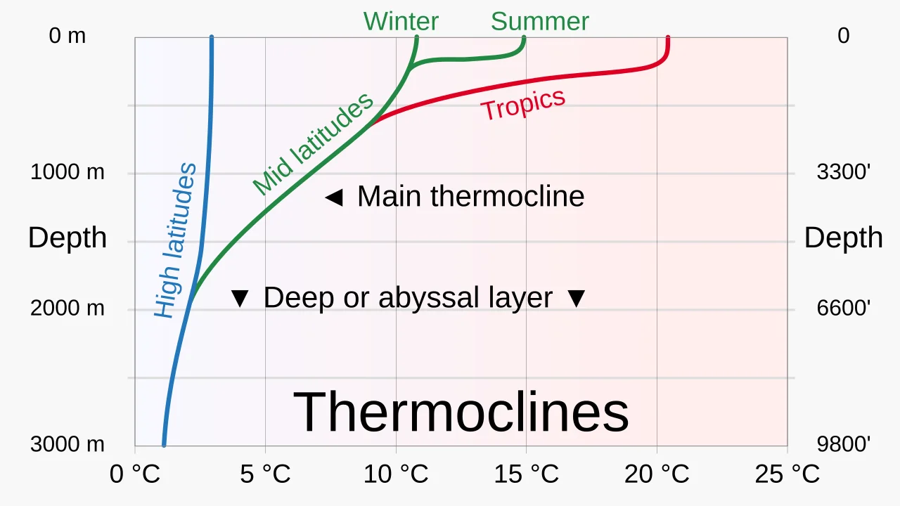
Vertical temperature distribution describes how seawater temperature changes from the surface towards the ocean floor. In tropical and many temperate regions, the ocean can be broadly divided into three thermal layers: the surface mixed layer, thermocline and deep-water layer.
1. Surface Mixed Layer
The surface mixed layer receives the greatest amount of solar energy and is in direct contact with the atmosphere. Winds, waves and turbulence mix the water, distributing heat through this upper layer.
Its depth and temperature vary with latitude, season and wind conditions. In tropical oceans, the surface layer remains relatively warm throughout the year, whereas in temperate regions it may become warmer and more strongly stratified during summer.
2. Thermocline
The thermocline is the layer in which temperature decreases rapidly with increasing depth. It separates the relatively warm upper waters from the colder deep ocean.
In tropical oceans, a permanent thermocline is generally well developed. In temperate regions, the thermocline may strengthen during summer and weaken during winter as surface cooling and wind-driven mixing redistribute heat. In polar oceans, where surface water is already cold, the thermocline may be weak or absent.
The thermocline is important because it limits the vertical transfer of heat between surface and deep waters. It also influences ocean circulation, nutrient movement and the availability of oxygen at different depths.
3. Deep-Water Layer
Below the thermocline, temperatures are generally low and change comparatively little with depth. Sunlight does not penetrate sufficiently to heat these waters directly, and much of the deep ocean remains close to freezing, although exact temperatures vary with location and water mass.
Deep-water temperatures are influenced by the formation and sinking of cold, dense water at high latitudes, as well as large-scale ocean circulation. This movement transports heat and dissolved substances through the ocean over long periods.
Vertical Temperature Pattern Across Latitudes
The three-layer model is most evident in tropical and many temperate oceans. In polar regions, the temperature difference between the surface and deeper water is often smaller, although local variations and subsurface warmer layers can occur.
The depth of the thermocline also varies between ocean basins and seasons. Therefore, the vertical distribution of temperature is not a uniform pattern throughout the world's oceans.
Diurnal and Annual Range of Ocean Temperature
The diurnal range refers to the difference between the highest and lowest temperatures recorded during a day, while the annual range refers to the difference between the warmest and coldest monthly mean temperatures over a year.
Both ranges are generally smaller in the oceans than over land because water has a high specific heat capacity and ocean currents distribute heat. Daily temperature changes are usually modest, although shallow coastal waters and calm conditions may experience greater fluctuations.
Annual temperature variations are generally larger at middle and high latitudes than in tropical regions. Prevailing winds, currents, cloud cover and seasonal mixing modify these patterns.
Significance of Ocean Temperature Distribution
Ocean temperature distribution has several important geographical and environmental implications.
Influence on ocean currents: Temperature contributes to differences in water density and, together with salinity, helps drive thermohaline circulation.
Climate regulation: Oceans absorb, store and redistribute heat, influencing coastal climates and atmospheric circulation.
Marine ecosystems: Temperature affects the distribution, reproduction and survival of marine organisms. Sharp temperature gradients can also influence the movement of nutrients and oxygen.
Fisheries and productivity: Cold-water upwelling brings nutrient-rich water towards the surface, supporting plankton growth and productive fishing grounds.
Tropical cyclones: Warm sea-surface temperatures provide energy to tropical cyclones. The depth of warm water is also important because storms can bring cooler subsurface water upwards and weaken their own energy supply.
Climate change: Rising ocean temperatures contribute to marine heatwaves, coral bleaching, changes in species distribution and the expansion of seawater through thermal expansion, which contributes to sea-level rise.
Conclusion
The temperature distribution of oceans is governed by the interaction of solar radiation, latitude, ocean currents, prevailing winds, vertical mixing, seasonal variations and ocean basin configuration. Horizontally, surface temperatures generally decrease towards the poles, while vertically, tropical and temperate oceans commonly exhibit a warm surface layer, a thermocline and cold deep water.
FAQs
1. What is the temperature distribution in oceans?
It refers to the variation in ocean water temperature across different latitudes, depths, seasons and regions.
2. What factors affect ocean temperature?
Major factors include:
- Latitude and solar radiation
- Prevailing winds
- Ocean currents
- Distribution of land and water
- Season and day length
- Depth and water mixing
3. What is the horizontal distribution of ocean temperature?
Horizontal distribution refers to temperature variations across the ocean surface. Generally, temperatures are higher near the equator and decrease towards the poles.
4. Why is ocean temperature higher near the equator?
The equatorial region receives relatively direct solar radiation throughout the year, resulting in higher average sea-surface temperatures.
5. How do ocean currents affect temperature distribution?
Warm currents raise temperatures along nearby coasts, while cold currents lower them. They also influence fog formation, rainfall and marine ecosystems.
Related reads.

Globalisation and Its Effects
09 Oct 2026 8 min

Tides in Oceanography
08 Oct 2026 7 min

Land Reforms in India
08 Oct 2026 8 min

The Mughal Art and Architecture
07 Oct 2026 9 min

Cold War, World History
07 Oct 2026 8 min

Rock-Cut Architecture in India
06 Oct 2026 7 min
Put it into practice
Reading is step one.
Turn what you've just read into exam-ready answers with mentor-led practice and our structured test series.